News

Site Investigation Survey - Norfolk Windfarm Boreas, Vanguard West, Vanguard East
Please be advised of this notice advising mariners of the site investigation survey of the Norfolk Boreas, Vanguard East and Vanguard West windfarms and export cable. The Noordhoek Pathfinder and Geo Ranger will be completing survey operations in UK waters. The surveys started in March 2023 and are scheduled to last until the end of June 2024 (subject to weather and additional scopes).
Show More

Floating LiDAR Buoy - Morgan (Generation Assets)
The Morgan floating LiDAR buoy has stopped functioning due to depleted batteries. Consequently, the navigation lantern and AIS transmitter are no longer fully operational. Recovery of the Morgan Floating LiDAR buoy is planned for the 26/04/24 onwards, weather permitting.
The Morgan floating LiDAR buoy has stopped functioning due to depleted batteries. Consequently, the navigation lantern and AIS transmitter are no longer fully operational. Recovery of the Morgan Floating LiDAR buoy is planned for the 26/04/24 onwards, weather permitting.
Updates will continue and a final notice of confirmation will be sent out once all equipment has been recovered from site.
See detailed map on our bulletin website
Fish Monitoring Survey Receiver Deployment - Spiorad na Mara offshore windfarm
Spiorad na Mara Ltd are looking to deploy a series of fish acoustic tagging receivers within the proposed Spiorad na Mara offshore windfarm array area (the Project site) by the vessel Walrus (details in attached) The receivers are planned to be deployed as per the map and coordinates table below for a period of 5 months.
Each receiver and mooring will not extend >3m from the seabed (See attached). All receiver units will all be of ‘acoustic release’ (Innovasea, AR) type with acoustic retrieval canister (ARC). There will therefore be no markers on the surface whilst the equipment is in situ. Markers will only be deployed when the equipment is to be retrieved and a work vessel is on site to retrieve the equipment.
Fishing within the array area is currently active throughout the site, alongside associated gear. However, it is required that vessels are to avoid deployment of gear, within the areas proposed for deployment of the monitoring devices.
See detailed map on our bulletin website
Component Exchange - Hywind Scotland Windfarm
Hywind Scotland windfarm will be undertaking a major component exchange on all 5 x Turbines starting 11th April 2024.
Hywind Scotland windfarm will be undertaking a major component exchange on all 5 x Turbines starting 11th April 2024.
This work will involve the complete disconnection of the mooring lines and electrical cabling which are lowered and temporarily secured to the seabed, prior to towing each turbine back to Wergeland in Gulen, Norway.
The project is due to last around 3 months in total however there should be some expectation of weather delays therefore some contingency should be applied to the planned dates.
See detailed map on our bulletin website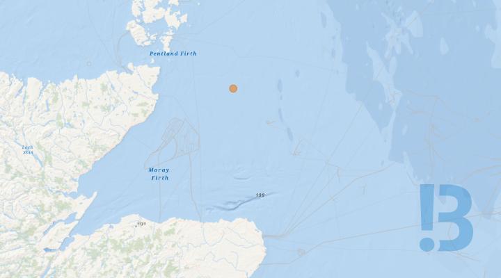
Metocean Buoy Maintenance - Stromar Offshore Windfarm
Mariners are advised Stromar Offshore Wind Farm will be servicing a Floating Lidar System within the boundary of the proposed Stromar array site. The device is marked with serial number E38.
Show More
Calibration Test - Thistle Wind Partners proposed Bowdun (E3) Offshore Wind Farm
Please be advised Thistle Wind Partners (TWP), will be undertaking a Geophysical survey of the proposed Bowdun (E3) Offshore Wind Farm export cable corridor in the comings weeks. Prior to the survey being undertaken the survey vessel will be required to undertake calibration tests of its survey equipment. The purpose of this notice is to outline the working area required for the survey vessel to undertake the calibration. The pre-survey calibration test will utilise the MV Ondine Jule.
Ondine will be conducting pre survey calibration tests. During the tests the Ondine Jule will be deposit calibration equipment on the seabed prior to carrying out test survey lines over the top of the in-site calibration equipment, operating at approximately 4 knots with equipment being towed at a distance of up to 300 m astern of the vessel. The vessels calibration will take up to 48hrs to complete, however, additional time has been acknowledged to accommodate weather and operational delays.
The vessel will be restricted in their ability to maneuver and will display the appropriate lights and shapes. Other vessels are requested to provide a minimum clearance of 500m from the survey vessel during marine operations, and pass at a safe speed. The survey vessels will monitor VHF Channel 16 at all times.
See detailed map on our bulletin website
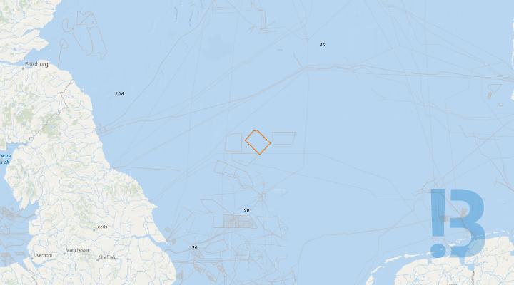
Metocean Equipment Deployments - Ossian Offshore Wind Farm
Partrac is planning to redeploy the LiDAR Buoy at Site 3, from 21st April 2024. The works are estimated to be carried out on one day, weather permitting.
Partrac Ltd. deployed FLS200 Floating LiDAR buoys at two sites (Sites 1 & 3) within the Ossian floating offshore wind farm off the East coast of Scotland in August 2022. Partrac is planning to redeploy the LiDAR Buoy at Site 3, from 21st April 2024. The works are estimated to be carried out on one day, weather permitting. The vessel to be used for the works is the Mar Fortune with call sign LEZI, MMSI Number 257011630 and IMO 9267273.
See detailed map on our bulletin website
Demarcation / Met-Ocean Buoys - Sofia Offshore Wind Farm
All Mariners are advised that from 1st May 2024 until further notice, the “Mar Fortune” will commence the service works as required on demarcation buoys within the Sofia Offshore array. The Kingdom of Fife commenced and continues with Met-Ocean & Demarcation maintenance works within the Sofia Export Cable Route and also within the Array. Works will last for approx. 14 days (weather permitting). Note: Vessel is currently off location, but expected back in field from around the 28th April 2024,
The Voe Earl is expected on site between the 18th April to 20th April 2024 for the service works on demarcation buoys marking the perimiter of the the Sofia Offshore array, including the reinstatement of the East Cardinal Buoy "E4".
The Met-ocean buoys at KP2 has already been removed and those metocean buoys at KP8 and KP40 on the Export Cable Route will also be permanently recovered during March 2024. There will also be an additional three Met-ocean buoys installed within the Sofia Offshore Windfarm Array as well as an additional met-ocean buoy at KP180 along the export cable route.
Vessels will be working daylight hours only and shall be monitoring VHF 16 during the scope of the works and shall also be exhibiting the correct day shapes and night lights for a vessel restricted in ability to manoeuvre.
Mariners are requested to refrain from entering and transiting through the construction area as demarcated by these demarcation buoys.
The table below provides a summary of each Cardinal and Special Mark Buoy deployed at the SOWF array, including target coordinates in WGS84 Degrees Decimal Minutes and a description of top mark and lantern characteristics. The Demarcation Buoys will be deployed for a period of approximately three years.
| Buoy | ID | Latitude | Longitude | Lantern Characteristics | Lantern Colour |
| North Cardinal | N1 | 55° 08.133’ N | 002° 09.518' E |
VQ 0.5s |
White |
| North Cardinal | N2 | 55° 08.436’ N | 002° 13.418’ E |
Q 1s |
White |
| East Cardinal | E1 | 55° 06.480’ N | 002° 16.929’ E |
Q(3) 10s |
White |
| East Cardinal | E2 | 55° 02.571’ N | 002° 23.925' E |
VQ(3) 5s |
White |
| East Cardinal | E3 | 54° 59.043’ N | 002° 30.269’ E |
Q(3) 10s |
White |
| East Cardinal | E4 | 54° 55.085’ N | 002° 26.631’ E |
VQ(3) 5s |
White |
| East Cardinal | E5 | 54° 51.523’ N | 002° 20.709' E |
Q(3) 10s |
White |
| South Cardinal | S1 | 54° 49.725’ N | 002° 16.726' E |
Q(6) + LFL 15s |
White |
| West Cardinal | W1 | 54° 51.829’ N | 002° 12.194' E |
Q(9) 15s |
White |
| West Cardinal | W2 | 54° 56.229’ N | 002° 03.867' E |
VQ(9) 10s |
White |
| West Cardinal | W3 | 55° 00.623’ N | 001° 56.196' E |
Q(9) 15s |
White |
| West Cardinal | W4 | 55° 04.648’ N | 002° 02.498' E |
VQ(9) 10s |
White |
| Special Mark | SP1 | 55° 02.741’ N | 001° 59.756' E |
FI Y 5s |
Yellow |
| Special Mark | SP2 | 55° 06.569’ N | 002° 05.756' E |
FI Y 5s |
Yellow |
| Special Mark | SP3 | 55° 04.525’ N | 002° 20.428' E |
FI Y 5s |
Yellow |
| Special Mark | SP4 | 55° 00.617’ N | 002° 27.418' E |
FI Y 5s |
Yellow |
| Special Mark | SP5 | 54° 56.871’ N | 002° 29.602' E |
FI Y 5s |
Yellow |
| Special Mark | SP6 | 54° 53.324’ N | 002° 23.621' E |
FI Y 5s |
Yellow |
| Special Mark | SP7 | 54° 54.030’ N | 002° 08.026' E |
FI Y 5s |
Yellow |
| Special Mark | SP8 | 54° 58.427’ N | 001° 59.703' E |
FI Y 5s |
Yellow |
The table below provides a summary of the Met-ocean Buoys deployed at the SOWF Array.
| Site Location | Buoy Position | Latitude | Longitude | Deployment Date | Recovery Date |
| Export Cable | KP2 (From Shore) | 54 36.508N | 001 00.175W | June 2023 | Now recovered |
| Export Cable | KP8 | 54 36.584N | 000 54.674W | June 2023 | Will be recovered permanently |
| Export Cable | KP40 | 54 40.524N | 000 26.735W | June 2023 | Will be recovered permanently |
| Export Cable | KP130 | 54 50.543N | 000 54.689E | June 2023 | Will remain in position until further notice |
| Export Cable | KP180 | TBC | TBC | March 2024 | Will remain in position until further notice |
| SOWF | Array North | 55° 5.392' N | 002° 12.993' E | June 2023 | Will remain in position until further notice |
| SOWF | Array South | 54° 54.987' N | 002° 15.585' E | June 2023 | Will remain in position until further notice |
| SOWF | Array East | 54° 58.160' N | 002° 22.521' E | March 2024 | Will remain in position until further notice |
| SOWF | Array West | 55° 01.528' N | 002° 04.052' E | March 2024 | Will remain in position until further notice |
| SOWF | OCP | 55° 00.439' N | 002° 14.798' E | March 2024 | Will remain in position until further notice |
See detailed map on our bulletin website

Geophysical Survey - Celtic Sea Pre-Consent Surveys
Geophysical survey activities undertaken by Kommandor Iona and Fugro Searcher in the Celtic Sea Project Development Areas (PDAs)
Survey vessels, Kommandor Iona and Fugro Searcher, will undertake Geophysical and UXO survey operations in the Celtic Sea. Kommandor Iona will commence survey operations on or around 29th April 2024. Fugro Searcher will join Kommandor Iona on or around 15th May 2024. Completion of the UXO and Geophysical survey phase is estimated to be 30th July 2024, progress permitting.
Each survey vessel will have a dedicated Fisheries Liaison Officers (FLO) onboard, who, with the support of Fishing Industry Representatives (FIR) onshore will provide live updates on vessel progress and immediate areas of operation throughout the course of the survey programme.
UXO survey operations will be carried out across all three PDAs. Kommandor Iona will commence UXO survey operations from 29th April and will run individual transects at multiple locations across each PDA.
Fugro Searcher will commence Geophysical survey operations on or around 15th May 2024. Kommandor Iona will also commence Geophysical survey operations once the UXO survey scope is complete. To assist with communicating survey vessel plans and locations to mariners, the PDAs have been split into smaller sub blocks documented in the attached Notice to Mariners. The survey vessels will work in separate sub blocks. Line orientations in all PDAs have main lines running northwest/southeast and cross lines running northeast/southwest. The survey lines cover the full extents of the PDAs.
Mariners are advised that the Kommandor Iona and Fugro Searcher may be found turning beyond the limit of the PDA boundaries. Therefore, a nominal 5km turning area has been identified around each PDA in all directions. This area is designated to provide sufficient space for the vessel to turn and navigate safely whilst towing deployed survey equipment as well as performing marine mammal mitigation procedures prior to acquiring data within the PDA survey blocks.
When towing survey instruments, the survey vessels will be restricted in ability to manoeuvre. Vessels will display the lights and shapes appropriate to their survey activities.
See detailed map on our bulletin website
Multibeam Bathymetric and side scan sonar survey - Walney 1 & 2 Export Cables
High-Resolution Multibeam Bathymetric and Side Scan Sonar survey of the Walney 1 & 2 Export Cables. Depending on weather and conditions Survey Operations are planned to commence shortly and can be expected to last for approx. 12 days. This survey will carried out by the 17meter catamaran ‘AMS PANTHER’ working on a 12hr daylight only basis from Fleetwood.
RE-SCHEDULED START TO THIS SURVEY
Attached is a Notice to Mariners issued by ULTRABEAM Ltd concerning a High-Resolution Multibeam Bathymetric and Side Scan Sonar survey of the Walney 1 & 2 Export Cables.
These Survey Operations were planned to commence on or around TUESDAY 12th MARCH but the continuing poor weather has caused delay with the survey vessel, the 17meter ‘AMS PANTHER’, remaining weather bound in Wicklow.
As long as weather and conditions remain stable ‘AMS PANTHER’ will transit into Fleetwood on Thursday 18th April and mobilize for survey during Friday 19th. and Saturday 20th.
SURVEY OPERATIONS ARE SCHEDULED TO START ON SUNDAY 21st. AND CAN BE EXPECTED TO RUN UNTIL TUESDAY 30th. APRIL
‘AMS PANTHER’ WILL BE WORKING ON A 12hr. DAYLIGHT ONLY BASIS FROM FLEETWOOD.
All MARINERS PLEASE NOTE that as these survey operations will consist of using high-resolution Multibeam Echo Sounders as well as the towing of Side Scan Sonar at lengths of up to 120m from the stern of the vessel, and along both Export Cables, a wide berth minimum 500 meters is requested whenever the vessel is on site and passing vessels are requested to reduce speed if possible.
A small chartlet showing the routes of the two Export Cables along the seabed, from the Sub-Station to the Landfall, as well as a picture of ‘AMS PANTHER’ are included with the NtM
IN THE LEAD UP TO AND FOR THE DURATION OF THIS SURVEY FISHERMEN ARE REQUESTED, AND ADVISED, NOT TO SET ANY GEAR CLOSE TO OR ALONG THE WHOLE LENGTH OF THE ABOVE MENTIONED EXPORT CABLES AND PLEASE RE-LOCATE ANY GEAR ALREADY IN CLOSE PROXIMITY – IF IN DOUBT PLEASE CONTACT ME
‘AMS PANTHER’ will keep a listening watch on VHF Channels 16 & 12 and can be contacted for information relating to vessel movements only.
PLEASE READ THE NOTICE
Page 1 : Shows a picture of ‘AMS PANTHER’
Page 2 ; Contents
Page 3 ; Project Summary along with small chartlet showing Export Cable Routes along with project information.
Pages 4 & 5 : Pictures and details of the Survey Vessel ‘AMS PANTHER’
Please note that the small chartlet on the attached NtM (Page 3) is provided for information purposes relating to this survey only and should not be used for navigation.
Please do not hesitate to contact me if you are unsure about any of the above or require any further information, also please pass this information to any of your colleagues who you think might be interested.
If you know of any fisherman who works the area and does not receive this information or anybody else who would benefit from this information please let me know.
……………………………………………………………………………………………….
FISHING INSIDE THE WIND FARM
If fishing inside the Wind Farm you are advised to use Dhan Buoys anchored towards the middle of the lane with a long weighted feed line rather than Marker Buoys that can be moved by the strong tides and so foul the Turbines.
For more information on the boundaries of the 50 metre Advisory Safety distances please ensure that you have the latest KIS-ORCA information installed - this can be downloaded from www.KIS-ORCA.eu
Please also consult the MMO website : https://www.gov.uk/guidance/marking-of-fishing-gear-retrieval-and-notification-of-lost-gear
If in any doubt please contact me
Regards : Tom Watson
Tel……….. Mobile 07903 173 624
See detailed map on our bulletin website
Metocean Equipment & FLiDAR Maintenance - Buchan Offshore Wind Farm
Mariners are advised that Partrac, on behalf of Buchan Offshore Wind, are conducting Maintenance activities on the metocean equipment and FLiDAR deployed in November 2022 within the Buchan Offshore Wind Project site, located off the East coast of Scotland.
Vessel mobilisation for these works is anticipated to be carried out from 23rd of April 2024, however please note this is subject to weather. Duration of works is estimated to be up to 2 days. The following equipment will be maintained: • 1 x Subsea mooring • 1 x FLiDAR Maintenance activities will include: • Visual Inspection, testing and replacing components as required; • Cleaning & regreasing; • Replace batteries; • Data download.
See detailed map on our bulletin website
Cable Landfall and Cable Lay Works - Sofia Offshore Wind Farm
All Mariners are advised that all works to reinstate the HDD trenches out to KP3 are suspended until May 2024. This means that the spoil heaps from 2023 back hoe excavation works will now remain in situ works resume, although a level of natural backfill is expected over this period.
The 2 Export Cables & 1 Fibre Optic Cable (all bundled) have been installed into the HDD ducts at Landfall (Marske by The Sea).
Guard vessels will remain be onsite 24 hours per day to monitor the export cable until approximately the end of Q2- 2024.
Exclusion zone coordinates for 2023 cable pull-in and cable lay works are detailed within the table above and attached Notice to Mariners (NtM).
The coordinates of the guard vessel locations for the cable pull-in and cable lay works for Campaign 1 are detailed within the table above and attached NtM.
Mariners are requested to remain where possible 500m from the vessels and leave a wide berth during the installation operations. Fishing vessels are requested to pass at a safe speed and distance and remain outside of the exclusion area identified.
Vessels will be monitoring VHF 16 during the scope of the works and shall also be exhibiting the correct day shapes/ lights and flag for vessels engaged in diving operations and restricted in ability to manoeuvre.
Special Marker Buoys (SMB) will be in place to mark the HDD works area and will remain in place until completion of the export cable landing activities. The locations of these SMBs are detailed in the above table and attached NtM.
***Within the working area there may be a temporary reduction in navigable depth up to 2m due to excavated material being placed in spoil heaps***
***Please note that the Ocean Energy (Multicat) has recovered 3 of the 4 (A / B / D) anchors from the seabed nearshore HDD Pits and only one anchor remains in situ on the seabed at the HDD Pit in position “C”***
The Ocean Energy (Multicat) may attempt to recover the remaining anchor (C) from the seabed nearshore HDD Pits.
Mariners are advised of the following vessels commencing operations at Sofia Offshore Wind Farm (SOWF).
| Vessel Name | Vessel Type | Length (m) | Beam (m) | Draft (m) | Gross Tonnage (T) | Call Sign | MMSI Number |
| Sancta Maria | Guard Vessel | 20.37 | 6 | 3.03 | 106 | 2FOV7 | 235093015 |
| Inge | Guard Vessel | 29.7 | 6.2 | 3.1 | 192 | YJSN5 | 577097000 |
| Jason II | Guard Vessel | 26.02 | 6.01 | 3.21 | 127 | MJFY4 | 232036020 |
| Dolfijn | Guard Vessel | 27 | 6.2 | 3.1 | 99 | YJQL8 | 576697000 |
| Mary Ann | Guard Vessel | 32.7 | 7 | 3.6 | 53 | YJTV2 | 577256000 |
| Venus II | Guard Vessel | 24 | 7.4 | 3.15 | 145 | HP9337 | 370046000 |
| Walvis | Guard Vessel | 27 | 6.4 | 3.32 | 108 | YJQG3 | 576448000 |
| Flamingo | Guard Vessel | 31 | 7 | 3.5 | 159 | YJVW2 | 576259000 |
| Haulbowline | Guard Vessel | 22.3 | 7 | 2.7 | 88 | MEZW9 | 232021354 |
| Star of Hope | Guard Vessel | 23.9 | 7.2 | 3.4 | 101 | MKDN2 | 232038483 |
| Karima | Guard Vessel | 26.10 | 6.0 | 4.0 | 88 | MPKV5 | 232006310 |
| Merlin Diver | Guard Vessel | 24.99 | 6.18 | 3.8 | 88 | YJQG4 | 576451000 |
| Enterprise II | Guard / Scout Vessel | 26 | 9.2 | 4.7 | 421 | MPFN7 | 232006130 |
The table below also provides the position and description of any equipment/asset/item that will remain in place following demobilisation of the Ievoli Ivory.
| Location | Equipment and Description | Latitude | Longitude | Approximate Depth (LAT) |
| A |
Concrete mattresses 3 of 5.95 m x 2.95 m x 0.30 m |
54°38.544’ N | 000°35.147’W | 55m |
| B |
Concrete mattresses 1 of 5.95 m x 2.95 m x 0.30 m |
54°38.572’ N | 000°35.142’W | 55m |
| C |
Concrete mattresses 2 of 5.95 m x 2.95 m x 0.30 m 1 of 5.55 m x 2.95 m x 0.50 m |
54°48.144’ N | 000°37.515’E | 74m |

Post-Lay Cable Burial Works - Sofia Offshore Wind Farm
All Mariners are advised that the Normand Pacific continues with post-lay cable burial works on the Sofia Export Cable. The exact finish dates will be dependent on the prevailing weather conditions and work progress. The Normand Pacific has now departed the project and is expected to return in Mid-June 2024 to recommence operations.
The post-lay burial (PLB) vessel “Normand Pacific” will be present for the entire scope of works. The Normand Pacific will transit from Middlesborough Support Depot and remain on site for 24hr operations. The PLB vessel will make passage to and from the support depot as required based on operational constraints.
The PLB will be supported by those guard vessels outlined in the table above. Guard vessels will remain be onsite 24 hours per day to monitor the export cable until approximately the end of Q2 - 2024.
Exclusion zone coordinates for the 2023 to 2024vpost-lay burial works are identified within the table above and remain the same for those during cable lay works as outlined in NtM 11 (rev 02).
The coordinates of the guard vessel locations for the post-lay burial works for Campaign 1 are detailed within the table above and attached NtM.
Please be aware that by virtue of mode of operation and the equipment deployed, the Normand Pacific will at times be Restricted in their Ability to Manoeuvre as defined under COLREGS (International Regulations for Preventing Collisions at Sea 1972 and shall be exhibiting the correct day shapes / lights for vessels restricted in ability to manoeuvre.
Mariners are requested to remain where possible 500m from vessels and equipment. Fishing vessels are requested to pass at a safe speed and distance and remain outside of the exclusion area identified. All vessels can be contacted on VHF 16 for further information as required reference proximity/nearby operations etc.
Mariners are advised of the following vessels operating at the Sofia Offshore Wind Farm (SOWF).
| Vessel Name | Vessel Type | Length (m) | Beam (m) | Draft (m) | Gross Tonnage (T) | Call Sign | MMSI Number |
| Normand Pacific | Post-Lay Cable Burial Vessel | 122 | 23 | 7.0 | 9778T | LAXI7 | 257743000 |
| Sancta Maria | Guard Vessel | 20.37 | 6 | 3.03 | 106 | 2FOV7 | 235093015 |
| Inge | Guard Vessel | 29.7 | 6.2 | 3.1 | 192 | YJSN5 | 577097000 |
| Jason II | Guard Vessel | 26.02 | 6.01 | 3.21 | 127 | MJFY4 | 232036020 |
| Dolfijn | Guard Vessel | 27 | 6.2 | 3.1 | 99 | YJQL8 | 576697000 |
| Mary Ann | Guard Vessel | 32.7 | 7 | 3.6 | 53 | YJTV2 | 577256000 |
| Venus II | Guard Vessel | 24 | 7.4 | 3.15 | 145 | HP9337 | 370046000 |
| Walvis | Guard Vessel | 27 | 6.4 | 3.32 | 108 | YJQG3 | 576448000 |
| Flamingo | Guard Vessel | 31 | 7 | 3.5 | 159 | YJVW2 | 576259000 |
| Haulbowline | Guard Vessel | 22.3 | 7 | 2.7 | 88 | MEZW9 | 232021354 |
| Star of Hope | Guard Vessel | 23.9 | 7.2 | 3.4 | 101 | MKDN2 | 232038483 |
| Karima | Guard Vessel | 26.10 | 6.0 | 4.0 | 88 | MPKV5 | 232006310 |
| Merlin Diver | Guard Vessel | 24.99 | 6.18 | 3.8 | 88 | YJQG4 | 576451000 |
| Enterprise II | Guard / Scout Vessel | 26 | 9.2 | 4.7 | 421 | MPFN7 | 232006130 |

Temporary Hazard - Sheringham Shoal Windfarm Export Cable Corridor
There is the potential that two separate lengths of export cable and ducting have become exposed on the seabed (export cable route from Sheringham Shoal Windfarm). Potentially this may create an unguarded snagging hazard of approximately 20m for each of the cables/locations identified. The planned survey on 8th April was cancelled due to weather. A further survey date is to be confirmed and this notice will be updated when details confirmed. The hazard notice remains active.
Show More

Array Boulder Clearance and Pre-trenching Works - Sofia Offshore Wind Farm
All Mariners are advised that that the ASSO Subsea vessel “TSV Aethra” continues with boulder clearance and pre-trenching works within the Sofia Offshore Wind Farm Array. The TSV Aethra departed site for dry dock on the 18th March 2024 and is expected to return to site on the 17th April 2024 to recommence operations.
The works are scheduled to be deployed during four visits to site (from Port of Blyth). Vessels are requested to leave a wide berth during the installation operations of at least 0.5 Nm.
The length of the boulder clearance and pre-trenching activities will vary depending on the execution progress, and details of any changes will be confirmed in further Notice to Mariners to be issued during the course of the project.
The table above provides the coordinates of the total working area of the boulder clearance and pre-trenching works at the SOWF array.
The TSV Aethra shall be monitoring VHF 77 during the scope of the works and shall also be exhibiting the correct day shapes and night lights for a vessel restricted in ability to manoeuvre.
**Note: In the exclusion zone, temporary reduction by approx. 1 meter in navigable depth might be created from the pre-plough spoil heaps.
| Vessel Name | Vessel Type | Length | Beam | Draft | Gross Tonnage | Call Sign | MMSI Number |
| TSV Aethra | Boulder Clearance and Pre-Trenching Vessel | 94.10m | 22m | 7.1m | 7,082 | SVDM6 | 241831000 |
| Enterprise II | Guard / Scout Vessel | 26.00m | 9.2m | 4.7m | 421 | MPFN7 | 232006130 |
See detailed map on our bulletin website
Sofia OWF - Foundation Installation Works & Noise Monitoring Works
All Mariners are advised from around the 20th April 2024, through week commencing 15th July 2024, the Baltic Explorer will Noise Monitoring works within the Sofia Offshore Wind Farm Array. The Wind Turbine Installation Vessel 'Aeolus' is also expected on site week commencing 15th April 2024, through week commencing 12th May 2024 to commence Foundation Installation Works within the array site.
Noise Monitoring Works (Baltic Explorer)
The Baltic Explorer will commence deployment, operation and retrieval of noise monitoring stations deployed within the Sofia Offshore Wind Farm Array. Five stations will be deployed for the purpose of noise monitoring during the first four monopile foundations installation. Each station consists of two chain anchor blocks, a buoy including a Fl (5) Y 20s navigation light with nominal range of 2nm, and a hydrophone. The noise monitoring buoy and mooring schematic are outlined within the relevant Notice to Mariners (NtMs).
Foundation Installation Works (Aeolus)
The Aeolus will commence the Offshore Foundation Transport and Installation works within the Sofia Offshore Wind Farm Array. These works include the transport and installation operations of primary components, namely Monopiles, and secondary components, namely Main Access Platforms, Internal Platforms, Boat Landings and Upper Ladders.
The Sofia Offshore Wind Farm Exclusion Zone coordinates, where the SSSV Baltic Explorer and WTIV Aeolus are going to operate are shown below and included within the relevant NtM. Mariners are requested to remain outside this Exclusion Zone.
Vessels are requested to pass at a safe speed and distance and fishing vessels are advised to remain outside of the areas identified.
SSSV Baltic Explorer and WTIV Aeolus will be transiting to Sofia Offshore Wind Farm field from port of Tyne in the UK.
See detailed map on our bulletin website
Sofia OWF - Offshore Converter Platform Survey Works
All Mariners are advised that the survey vessel “Glomar Supporter” will be undertaking non-intrusive seabed survey works within the Sofia Array. Works are expected to commence week commencing 22nd April 2024 and are expected to take approx.7days (weather permitting).
The Glomar Supporter shall be operating within the Sofia OWF Exclusion Zone coordinates, as detailed below.
The Glomar Supporter shall be exhibiting day signals and night lights identifying a Vessel Restricted in its Ability to Manoeuvre. All vessels are requested to give a wide berth. Glomar Supporter can be contacted on VHF 16 when infield.
Glomar Supporter will be transiting to Sofia Offshore Wind Farm from Great Yarmouth.
See detailed map on our bulletin website
Nearshore Water Sampling - Stromar Offshore Wind Farm
Mariners are advised Stromar Offshore Wind Farm are undertaking nearshore water sampling from approximately Thursday 18 April 2024 in the Moray Firth near Fraserburgh, Scotland for one to two days. The survey vessel Seren Las will attend to a number of sampling stations within the survey box.
Show More

Asset Preservation Campaign - Dogger Bank A Offshore Wind Farm
The Service Operations Vessel, (SOV) Edda Boreas, will carry out Balance of Plant (BoP) and Asset Preservation operations within Dogger Bank A construction site. The works will be performed in a single campaign, commencing on the 6th of November 2022 and continuing until approximately Q2 2024. The works will be continuous, 24 hours a day.
The operations will include visual inspections and maintenance at installed WTG foundation locations. During operations, the Edda Boreas will be restricted in its ability to manoeuvre as defined under COLREGs (International Regulations for Preventing Collisions at Sea 1972) and will display the appropriate day shapes and lights. The vessel will also transmit an Automatic Identification System (AIS) message. It is requested that all vessels maintain a minimum of 500m separation distance from the Offshore Supply Vessel and pass at reduced speed. Fishing gear or other equipment with seabed intervention should not be deployed when approaching the working area.
See detailed map on our bulletin website
Dogger Bank C Export Cable Installation, Campaign 1
The cable laying vessel, NKT Victoria, is currently installing the Dogger Bank C export cable in the Southern North Sea in three sections. Concrete mattresses are also being installed at the Langeled and SEAL pipeline crossings and the DBB power cable crossing.
The work will be performed in three Campaigns, with Campaign 1 covered by this NtM starting on 09th April 2024 and continuing until approximately 29th April 2024. The work will be continuous, 24 hours a day. Coordinates and chart of the route are provided below. Campaign 1 has started with the installation of concrete mattresses at the Langeled and SEAL pipeline crossings and DBB power cable crossing. The mattresses being installed by NKT Victoria immediately prior to cable installation. A guard vessel will be placed at crossing locations as soon as the mattresses have been installed. Starting from KP91, cable lay vessel NKT Victoria will then simultaneously lay and burial the export cable in a seaward direction to approximately KP177. Cable will be surface laid at the start and end of this section as well as at the crossings and where seabed conditions are otherwise unsuitable for simultaneous lay and burial. The second and third campaigns will separately comprise cable installation between landfall at KP0 and KP91 (campaign 2), and then KP177 and the Dogger Bank C Wind Farm. These campaigns will take place in August through October 2024 and will be covered in a future update to this NtM During operations the NKT Victoria will be restricted in its ability to manoeuvre as defined under COLREGs (International Regulations for Preventing Collisions at Sea 1972) and will display the appropriate day shapes and lights. The vessel will also transmit an Automatic Identification System (AIS) message.
It is requested that all vessels maintain a minimum of 1.5Nm separation distance from the Cable laying vessel and pass at reduced speed. Fishing gear or other equipment with seabed intervention should not be deployed when approaching the working corridor. An Offshore Fisheries Liaison Officer will be onboard NKT Victoria to provide support and coordination to fishing vessels, please see contact details below. In the period between cable lay operation until the cable has been permanently protected by means of burial or rock placement, the cable may be locally exposed on the seafloor and the construction working corridor will remain closed for any static fishing, anchoring or use of other equipment with seabed intervention. During this time the cable is sensitive to any external impact and constitutes a snagging risk for anchoring, fishing gear or other equipment with seabed intervention. To protect the cable in the 900m working corridor, guard vessels will be deployed along the route (described in a separate NtM LF700013-ESI-DOG-NOT-0008). The primary purpose of the guard vessels is to protect the exposed cable along the Dogger Bank C Export Cable corridor by monitoring and issuing warnings to marine traffic operating within 6Nm of the construction area with a Closest Point of Approach (CPA) < 1.5Nm.
See detailed map on our bulletin website
Offshore Construction - Dogger Bank B Offshore Wind Farm
Offshore Construction of the Dogger Bank B Offshore Wind Farm commenced on the 21st of April 2023 with the installation of the OSP jacket foundation. This notice will be updated weekly, giving information on the progress and resources involved in the offshore project. The intention is to give an overview of activities and vessels involved. Should anyone have questions regarding the operations, we kindly ask you to put them forward well in advance.
In the Second of two phases, the offshore installation vessel, HLV Saipem 7000, has completed installation the DBB Offshore Substation Platform (OSP) Topside within the Dogger Bank B construction area. The works commenced on approximately the 07th of April 2024, continuing until approximately the 17th of April 2024. The works will be continuous 24 hours a day. During operations, the HLV Saipem 7000 is restricted in its ability to manoeuvre as defined under COLREGs (International Regulations for Preventing Collisions at Sea 1972) and will display the appropriate day shapes and lights. The vessel will also transmit an Automatic Identification System (AIS) message. Anchor handling tugs, Fram Prince and Atlantic Kestrel will recover the 12 anchors currently deployed in an area up to 2km radius from OSP installation location. A Statutory Safety zone of 500m radius is in place around the HLV Saipem 7000. Due to the deployed anchors however, vessels are requested to maintain a minimum safe passing distance of 2km from the Saipem 7000 during the ongoing operations.
OSP Commissioning works
The DBB Offshore Substation Platform (OSP) will undergo a Commissioning phase within the Dogger Bank B construction area. The Jack up Vessel (JUV) HEA Leviathan will jack up and connect to the DBB OSP by a fixed gangway. The HEA Leviathan will remain on site during the Commissioning phase, acting as the accommodation platform and OSP emergency evacuation vessel.
The works will commence on approximately the 17th of April 2024, continuing until approximately 31st of August 2023. The works will be continuous 24 hours a day. During operations, a Statutory Safety zone of 500m radius will be in place around the HEA Leviathan for the duration of the Commissioning phase of the DBA OSP. Vessels are requested to maintain a minimum safe passing distance of 1km from the HEA Leviathan during the operation.
See detailed map on our bulletin website
Metocean Equipment Deployment
Partrac, on behalf of The Crown Estate, will deploy an array of Metocean equipment, including three Floating LiDAR (EOLOS FLS200) buoys, as part of a Metocean Survey. The equipment will be deployed at three sites located off the coast of Wales and Southwest England for a period of 12 months (excluding servicing). The equipment will be deployed in two phases: Site 3A & 4A (English waters) from w/c 22nd April 2024 (subject to weather). Site 1A (Welsh waters) from Mid July 2024 (DATE TBC).
Mariners are advised that Partrac, on behalf of The Crown Estate, will deploy an array of Metocean equipment, including three Floating LiDAR (EOLOS FLS200) buoys, as part of a Metocean Survey. The equipment will be deployed within three Project Development Areas (PDAs) located off the coast of Wales and Southwest England.
The equipment will be deployed across two phases:
- Site 3A & 4A (within English waters) from w/c 22nd April 2024 for a period of a year. (subject to weather)
- Site 1A (within Welsh waters) from Mid July 2024 for a period of a year. (DATE TBC)
Vessel mobilisation for the deployment is anticipated to be carried out on or after the w/c 22nd April 2024 (subject to weather) for English water deployment and Mid July 2024 (DATE TBC) for Welsh water deployment, weather permitting using the Kingdom of Fife. The duration of the deployment works is estimated to be 2 days, excluding weather downtime.
See detailed map on our bulletin website
Anchor on Seabed - Dogger Bank A Offshore Windfarm
An anchor and part of the shaft remains on the seabed at a depth of 26m at 'spare' WTG location on the periphery of Dogger Bank A Offshore Windfarm.
Show More

Maintenance Works ANS1 Minsmere & ANS2/ANS3 Lowestoft - Hornsea Project Three Offshore Wind Farm
Please find attached two Notice to Mariners for upcoming maintenance works on the artificial nesting structures (ANS) on behalf of the Hornsea Project Three Offshore Wind Farm in Lowestoft and Minsmere. The estimated duration of works is one week from the w/c 8th April 2024 (subject to conditions).
Mariners are advised that Orsted Hornsea Project Three (UK) Limited (hereafter ‘Orsted’) are attending site to perform routine maintenace at:
- ANS1, Minsmere
- ANS2, Lowestoft
- ANS3, Lowestoft
The maintenance will be undertaken on the kittiwake artificial nesting structure which was constructed as part of a compensation scheme associated with the Hornsea Project Three Offshore Wind Farm (Hornsea Three) project, located within the UK Sector of the North Sea. Hornsea Three are undertaking annual maintenance of the ANS structure in accordance with Marine Licence L/2022/009523/1.
See detailed map on our bulletin website
Dogger Bank A and B Boundary Buoy As-Installed Locations
The NLV Pharos has completed a limited construction boundary demarcation buoy removal and relocation operation on the Dogger Bank A and B boundary demarcation buoys in the Southern North Sea. The resultant boundary buoy deployment now marks both DBA and DBB as one large construction site.
The operation included the removal of 2 previously deployed Special Marks from DBA and 3 from DBB. The DBB SP10 Special Mark has been re-located. A total of 32 construction boundary demarcation buoys will remain in location until the windfarm construction activities have been completed and handed over to the Operations and Maintenance teams. Once the permanent Aids to Navigation (AtoN) have been installed on the WTGs, Trinity House will approve the permanent AtoN and the boundary buoys will be removed. If anyone finds a buoy that is off station or encounters a buoy location where it is not functioning or is missing, they should report this to the Dogger Bank Duty Marine Coordinator as soon as possible.
See detailed map on our bulletin website
Shetland HVDC Cable Survey
Scottish & Southern Electricity Networks - Transmission are proposing to survey the Shetland HVDC Cable. As such Roving Eye Enterprises have been commissioned to undertake a visual survey of the Shetland HVDC. The survey works will be opportunistic based on vessel availability and weather. The works will take approximately 2 days (day light hours only) to complete, during which mariners are advised to stay a minimum of 1000m clear of the vessel.
Scottish & Southern Electricity Networks has an obligation to survey its subsea cables, to ensure that they remain buried and protected so that the safety of other mariners and security of electricity supply is maintained. Please be aware that the vessel, Athenia, will be restricted in her ability to maneuver as defined under COLREGS (International Regulations for Preventing Collisions at Sea 1972). Masters of vessel are therefore requested to maintain their vessels at a minimum safe passing distance of 1000m.
See detailed map on our bulletin website
Offshore Construction - Dogger Bank A Offshore Wind Farm
Offshore Construction of the Dogger Bank A Offshore Wind Farm commenced on the 18th of March 2022. The development of the windfarm is made up of several elements - current ongoing elements are described below in the 'full notice' and in the attached file. This notice will be updated weekly, giving information on the progress and resources involved in the offshore project.
The development of the windfarm is made up of several elements - current ongoing elements include:
The Offshore installation vessel, HLV Seaway Strashnov has completed installation of all 95 monopile foundations, within the Dogger Bank A construction area.
The installed monopiles will be marked with temporary lighting with the following characteristics:
• Flashing (Fl) Yellow (Y) 2.5 seconds (s)
• IALA Availability Category 2 (not less than 99.0%)
• 360° visibility – up to two lights per structure may be used to achieve this
• At least 2 nm range.
The HLV Alfa Lift will continue TP installation in the Dogger Bank construction area.
Temporary lighting on 5 installed monopiles is currently inoperative (NtM LF500013-MIP-DOG-NOT-0026 NtM-DBA Monopiles unlit refers)
Construction Support Activities
The Offshore Construction Support Vessels, Edda Boreas, Grampian Tees, Grampian Derwent, Grampian Tyne and IWS Skywalker will carry out construction support activities within Dogger Bank A construction site.
The works will be performed in a single campaign, commencing on the 6th of November 2022 and continuing until approximately 30th September 2023. The works will be continuous, 24 hours a day.
Wind Turbine Generator (WTG) Installation
The Jack-up WTG Installation Vessel, Voltaire, will install wind turbine generators (WTG) within the Dogger Bank A construction area.
The Jack-up WTG Installation Vessel, Voltaire, will install wind turbine generators (WTG) within the Dogger Bank A construction area. the Voltaire has completed scheduled maintenance and will return to WTG Installation operations later this month, initially calling at Able Seaton port to loadout WTGs
The works commenced on the 18th of July 2023, continuing until approximately Q4 2024. The works will be continuous, 24 hours a day. A running list of the completed WTG installations and the next locations to be installed is presented in the Installation progress table in the WNoO.
See detailed map on our bulletin website
Geotechnical Survey - Berwick Bank Wind Farm
Mariners are advised that SSE Renewables will be returning to Berwick Bank Wind Farm area to undertake further Geotechnical survey work. The survey will be within the proposed Berwick Bank Wind Farm site boundary. It should be noted that SSE Renewables are not expecting fishermen to relocate gear - on this occasion the vessel(s) will work around any gear on location. A guard vessel will also be contracted to work alongside each survey vessel.
Update - the Fugro Scout has now demobilised from the survey area. The Fugro Quest continues to operate within the site until approximately the 23 April 2024 weather conditions permitting.
The survey work is being undertaken by Fugro and will be conducted from two vessels: the Scout and the Quest. The geotechnical survey is due to start on 27 October 2023. The scouting/guard vessel will be the Morning Dawn.
Survey Duration
The survey will mobilise 27 October 2023 lasting approximately 5 months. To account for all eventualities, we would like to extend the duration to 30 April 2024.
Survey Tasks
The survey will involve borehole sampling, using the Geobor-S coring system or similar, with the number and location of the boreholes yet to be finalised.
As a consequence of equipment being deployed and the modes of operation, all mariners are advised to keep a safe clearance distance of no less than 500metres from the vessel(s). No towed equipment will be used.
See detailed map on our bulletin website
Broadshore Wind Farm - Metocean buoy Investigation
Eolos has deployed two floating LiDAR Devices offshore Scotland for the acquisition of Wind and Metocean Data for a minimum period of 24 months.
Eolos has deployed two (2) Floating LiDAR Devices offshore Scotland for the acquisition of Wind and Metocean Data for a minimum period of 24 months.
The units deployed are:
- FLS200 E25 (deployed 09 Apr 2023); and
- FLS200 E26 (deployed 08 Apr 2023)
Metocean buoy
Illustrative figures showing the buoy dimensions and general arrangement are provided in the attached NtM.
Once in the water the top of the tallest mast is around 4 meters above the sea level.
The buoy is fitted with the following navigational safety features:
- Buoy painted yellow in colour;
- Yellow St Andrews Cross;
- Radar reflector;
- AIS AtoN (with MMSI 992351405, corresponding to Broadshore FLIDAR E26); and
- Marine lantern (with flash character Fl (5) Y 20s - 5 yellow flashes every 20 seconds) with a range of 5 nautical miles.
Mooring design
The buoy drifting radius is approximately 240 m from its deployment position. All material will be removed from the seabed after the measurement campaign is complete. The mooring layout design is provided on the final page of this document. The mooring layout design is provided as the final page of the attached NtM.
See detailed map on our bulletin website

Moray West Wind Farm - Array cable burial
Scope of work includes the jet trenching of array cables between the Wind Turbine Generator foundations and Offshore Substation foundations. Also an ROV survey of the array cable routes post burial will conducted.
Please be aware that, during the cable burial work and activities, by virtue of its mode of operation the North Sea Enabler will be Restricted in her Ability to Manoeuvre (RAM) and will also display the appropriate day shapes while conducting cable installaiton operations are taking place as defined under COLREGs (International Regulations for Preventing Collisions at Sea 1972, Rule 3).
Masters of approaching vessels are therefore requested to maintain their vessels and gears at a minimum safe passing distance from the vessel of 500 metres when it is undertaking work and
showing the appropriate shapes and lights in accordance with COLREGs Rule 27 to not compromise the safety of the ‘North Sea Enabler and their crew, and the ability to undertake its contracted
works.
See detailed map on our bulletin website
Geophysical Survey - Berwick Bank Wind Farm
Following weather delays, mariners are advise that SSE Renewables would like to extend the validity of this geophysical survey notice to 25 April 2024, taking place within the Berwick Bank Wind Farm turbine array area. A guard vessel will continue to operate ahead of the survey vessel, from 08 April 2024 onwards, this will be the Courage (SH170).
The survey will focus upon the north west quarter of the site with possible survey in the southern half of the site pending weather and survey progress. SSE Renewables are engaging with static gear fishers operating within the north western quarter of the site to arrange relocation of gear. A guard vessel with an onboard fisheries liaison officer (OFLO) will be present to work alongside the survey vessel. The survey work is being undertaken by Green Rebel and will be conducted by the Roman Rebel vessel. Pending weather conditions vessels are due to be on site from 28 February 2024. The scouting/guard vessel will be the GV Courage SH170 (up to 14th March) and the Shemarah II LH65 (from 13th March onwards).
The survey was anticipated to take approximately 2 weeks however following weather delays and we now would like to extend the duration of this notice validity to 25th April 2024.
Please note that towed equipment will be used. The survey will involve towing and deployment of: • Multi Beam Echosounder – to 3D map seafloor and calculate water depths; • Ultra-High Resolution Seismic (UHRS) – to provide data on conditions beneath the seabed; • Side Scan Sonar – to detect seabed objects; • Sub-bottom profiler – to provide data on conditions beneath the seabed; • Magnetometer – to detect any ferrous metal objects (wrecks / unexploded ordnance); • Ultra Short Baseline – to assist in positioning of the subsea equipment being towed / submerged.
As a consequence of equipment being deployed and the modes of operation, all mariners are advised to keep a safe clearance distance of no less than 500 m from the vessel(s). There will be an Offshore Fisheries Liaison Officer on board the guard vessel as well as an Onshore Fisheries Liaison Officer to account for 24 hour survey operations
See detailed map on our bulletin website
Floating LiDAR Buoys - Campion Wind
CampionWind Offshore Wind Farm Floating LIDAR (FLiDAR) Campaign will be extending a campaign to service FLiDAR Buoy SWLB060 between the 17th February and 30th April 2024. Following servicing the FLiDAR Buoy SWLB060 will remain mobilised until the 30th September 2024.
Mariners are advised that CampionWind Limited (a 50/50 Joint Venture company between ScottishPower Renewables UK Limited and Shell New Energies Holding Limited) will be carrying out servicing activities on FLiDAR Buoy SWLB060 between the 17th February and the 30th April 2024 (depending on weather conditions).
Following servicing the FLiDAR Buoy SWLB060 will remain mobilised until the 30th September 2024.
Servicing activities will comprise of the following steps: − Temporary retrieval of the FLiDAR Buoy SWLB060 for transport to Aberdeen for servicing; − Collection of FLiDAR Buoy SWLB060 in Aberdeen for onsite redeployment.
The FLiDAR Buoy will be monitored remotely so that in the event of a mooring failure, a team can be mobilised to carry out recovery and re-deployment activities. The Seawatch FLiDAR Buoy is yellow in colour and will exhibit a navigation light according to IALA standards: five (5) flashes at one (1) Hertz, every twenty (20) seconds (Fl (5) Y 20s). The ranges for the light on the Buoy is 5 nautical miles.
The FLiDAR Buoys location is outlined below and displayed within the Notice to Mariners (provided as an attachment to this notice). This location is within the CampionWind offshore wind farm array area, off the east coast of Scotland.
CampionWind will not seek to submit an updated AIS licence to support this extended mobilisation as the existing AIS Licence (1280449/3) is valid until September 2027.
See detailed map on our bulletin website

Metocean and Floating LiDAR Campaign extension - MarramWind Offshore Wind Farm
MarramWind Offshore Wind Farm Floating LiDAR (FLiDAR) Campaign will be extending a campaign to service FLiDAR Buoy WS198 between the 17th February and the 30th April. FLiDAR Buoy WS198 will remain mobilised until 30th September 2024. The Seawatch Midi Metocean buoy and FLiDAR Buoy SWLB56 were successfully demobilised on the 26th February 2024.
Mariners are advised that MarramWind Limited (a 50/50 Joint Venture company between ScottishPower Renewables UK Limited and Shell New Energies Holding Limited) will be conducting a service visit for the FLiDAR Buoy WS198 commencing from 17th February to the 30th April 2024 (depending on weather conditions).
Following servicing the FLiDAR Buoy WS198 will remain mobilised until the 30th September 2024.
Servicing activities will comprise of the following steps:
− Temporary retrieval of the FLiDAR Buoys WS198 for transport to Aberdeen for servicing;
− Collection of FLiDAR Buoy WS198 in Aberdeen for onsite redeployment.
All locations referred to are outlined in a table and displayed in Figure 1 within the Notice to Mariners (provided as an attachment to this notice). These locations are all within the MarramWind offshore wind farm 75 km off the east coast of Scotland.
FLiDAR Buoy WS198 is yellow in colour and will exhibit a navigation light according to IALA standards: five (5) flashes at one (1) Hertz, every twenty (20) seconds (Fl (5) Y 20s). The ranges for the lights on the buoy is 5 nautical miles.
Further details can be found within the attached Notice to Mariners.
See detailed map on our bulletin website
Foundation Installation Campaign - Dogger Bank A Offshore Wind Farm
The Offshore installation vessel, HLV Seaway Strashnov, and the Heavy Lift Crane Vessel, Seaway Alfa Lift will install offshore wind turbine foundations, within the Dogger Bank A construction area.
The works will commenced on the 26th of September 2022, continuing until approximately Q1 2024 The works will be continuous 24 hours a day. A running list of the next locations to be installed and completed foundation locations are presented in the Weekly Notice of Operations.
The installed monopiles are marked with temporary lighting with the following characteristics:
• Flashing (Fl) Yellow (Y) 2.5 seconds (s)
• IALA Availability Category 2 (not less than 99.0%)
• 360° visibility – up to two lights per structure may be used to achieve this
• At least 2 nm range.
During operations, the HLV Seaway Strashnov and the Seaway Alfa Lift will be restricted in ability to manoeuvre as defined under COLREGs (International Regulations for Preventing Collisions at Sea 1972) and will display the appropriate day shapes and lights. The vessels will also transmit an Automatic Identification System (AIS) message.
During operations, a Statutory Safety zone of 500m radius will be in place around the HLV Seaway Strashnov and the Seaway Alfa Lift during the installation of foundations. The safety zones will be monitored by a guard vessel. The primary response will be to warn passing traffic of the ongoing works and any active safety zones, and to alert any vessels where an infringement may occur or has occurred.
See detailed map on our bulletin website
Foundation Installation Campaign - Dogger Bank B Offshore Wind Farm
The Offshore installation vessel, HLV Seaway Strashnov, will install mono-pile foundations in the Dogger Bank B offshore windfarm construction area
The works will commence on the 17th of April 2024, continuing until approximately Q3 2024. The works will be continuous 24 hours a day. A chart of the DBB construction area and the foundation locations are provided below. A running list of the next locations to be installed and mono-piled locations are presented in the Weekly Notice of Operations.
The installed monopiles will be marked with temporary lighting with the following characteristics:
• Flashing (Fl) Yellow (Y) 2.5 seconds (s)
• IALA Availability Category 2 (not less than 99.0%)
• 360° visibility – up to two lights per structure may be used to achieve this
• At least 2 nm range.
During operations, the HLV Seaway Strashnov will be restricted in ability to manoeuvre as defined under COLREGs (International Regulations for Preventing Collisions at Sea 1972) and will display the appropriate day shapes and lights. The vessels will also transmit an Automatic Identification System (AIS) message.
During operations, a Statutory Safety zone of 500m radius will be in place around the HLV Seaway Strashnov. The safety zones will be monitored by a guard vessel. The primary response will be to warn passing traffic of the ongoing works and any active safety zones, and to alert any vessels where an infringement may occur or has occurred
See detailed map on our bulletin website
OSP Commissioning - Dogger Bank B Offshore Wind Farm
The Dogger Bank B Offshore Substation Platform (OSP) will undergo a Commissioning phase within the Dogger Bank B construction area
The Jack up Vessel (JUV) HEA Leviathan will jack up and connect to the DBB OSP by a fixed gangway. The HEA Leviathan will remain on site during the Commissioning phase, acting as the accommodation platform and OSP emergency evacuation vessel.
The works will commence on approximately the 19th of April 2024, continuing until approximately 17th August 2024. The works will be continuous 24 hours a day.
During operations, a Statutory Safety zone of 500m radius will be in place around the HEA Leviathan for the duration of the Commissioning phase of the DBB OSP. Vessels are requested to maintain a minimum safe passing distance of 1km from the HEA Leviathan during the operation.
The Platform Supply Vessel (PSV) SAR Loke will support the HEA Leviathan, carrying out regular supply runs to the offshore site.
See detailed map on our bulletin website
Foundation Installation Underwater Noise Monitoring -Dogger Bank B Offshore Wind Farm
On behalf of Dogger Bank Windfarm, Subacoustech Environmental Ltd will carry out underwater noise monitoring during the first five mono-piling operations to install foundation monopiles using the Service Operations Vessel, Edda Boreas, within the Dogger Bank B construction area
The works will commence on the 14th of April 2024, continuing until the first twelve piling operations are complete. The works will be continuous, 24 hours a day.
For each monitored piling event, the Edda Boreas will deploy a transect of up to four hydrophones on the seabed. The distances have been set at 750m, 1,500m, 5,000m and 10,000m from the piling site. Noise measurement equipment will consist of Autonomous Recording Units (ARUs) with one low sensitivity (Hi-SPL) hydrophone per unit at an approximate 2/3rd water depth. Each ARU will be moored by a fixed weight to the seabed. Equipment will be deployed prior to the start of piling operations and will be retrieved after completion.
During operations, the Edda Boreas will be restricted in its ability to manoeuvre as defined under COLREGs (International Regulations for Preventing Collisions at Sea 1972) and will display the appropriate day shapes and lights. The vessel will also transmit an Automatic Identification System (AIS) message.
It is requested that all vessels maintain a minimum of 500m separation distance from the Edda Boreas and pass at reduced speed
See detailed map on our bulletin website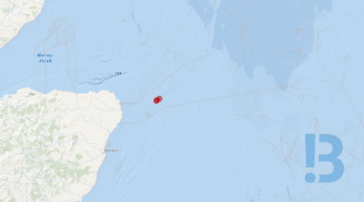
Metocean Survey - Salamander Offshore Wind Farm
FLiDAR 2 buoy SWLB086 has detached from its mooring and is currently drifting. The Green Isle (2IAV3) is currently on its way to recover the buoy this evening and bring to shore. The buoy is still operating and is being tracked. The buoy is equipped with AIS (MMSI 992351430). It has a yellow float (2.8 m wide) with black mast. The mooring and clump weight anchor that FLiDAR 2 buoy was attached to is assumed to be on the seabed as per the as-laid coordinates; it could present a snagging hazard.
Planned deployment within the Salamander Offshore Array Area consists of:
- 2x Fugro Sea-watch LiDAR Buoys (SWLB079 and SWLB086)
- 1x Fugro Wavescan Metocean Buoy (WS164) with a Nortek Signature 250 kHz Acoustic Doppler Current Profiler (ADCP) on the keel weight.
Illustrative figures showing the buoy dimensions and general mooring arrangement are provided in the attached NtM.
Once in the water the top of the tallest mast is around 4 meters above the sea level. The buoys' drifting radius is approximately 240 m from their deployment positions.
The buoys are fitted with the following navigational safety features:
- Buoys painted yellow in colour;
- Yellow St Andrews Cross;
- Passive radar reflector (Mobri S-4);
- AIS AtoN (with MMSI numbers: 992351428, 992351430, 992351429); and
- Marine lantern (with flash character Fl (5) Y 20s - 5 yellow flashes every 20 seconds) with a range of 4 nautical miles.

Benthic Survey - Thistle Wind Partners proposed (E3) Offshore Wind Farm
Thistle Wind Partners are developing the proposed Bowdun (E3) Offshore Wind Farm. Please be advised that Ocean Ecology Ltd (OEL), on behalf of Thistle Wind Partners (TWP), is undertaking a benthic survey of the proposed Bowdun (E3) Offshore Wind Farm Array Area and Export Cable Corridor. The purpose of this Notice to Mariners (NtM) is to outline the working area for the survey vessel, as well as the scope of work. The survey will utilise the vessel DSV Curtis Marshall.
Ocean Ecology Ltd (OEL) will be undertaking a benthic characterisation survey inclusive of a drop-down camera assessment, seabed grabs and water sampling. The survey operations do not involve towed survey equipment. The works will be completed by personnel from OEL onboard the vessel DSV Curtis Marshall. Works will be carried out on a continuous basis, 24-hours per day, seven days a week.
See detailed map on our bulletin website
Remedial Works - Islay – Orsay
Please be advised that Briggs Marine Contractors (on behalf of SHEPD) will be undertaking remedial works to a subsea electricity cable. The work will be carried out between low and high water on the shores on Islay and Orsay.
Please be advised that Briggs Marine Contractors (on behalf of SHEPD) will be undertaking remedial works to a subsea electricity cable. The work will be carried out between low and high water on the shores on Islay and Orsay.
Remedial works at Islay and Orsay landfalls will commence Friday 23rd - 24th April and are expected to take 2 days to complete.
Work Description
Site personnel will be installing cast iron split pipe to exposed sections of subsea cable between low and high water at both Islay and Orsay landfalls. The exposed subsea cable on the Islay landfall will also be reburied by utilising an excavator (where ground conditions permit). A pioneer support boat will also be utilised to offer support to personnel at each landfall. Operations will be conducted during daylight hours only and are weather/tide dependent.
See detailed map on our bulletin website
SHEPD Subsea Inspections - Orkney Islands
Please be advised that Aspect Land & Hydrographic Surveys Ltd (on behalf of SHEPD) will be undertaking subsea inspections of several cables across the Orkney Islands.
Please be advised that Aspect Land & Hydrographic Surveys Ltd (on behalf of SHEPD) will be undertaking subsea inspections of several cables across the Orkney Islands.
The inspection works will be centred on a 50m cable corridor, defined by the start and end coordinates listed in the attached NtM.
VESSEL DETAILS
The vessel [Offshore Sensor] to be used during the survey and inspection campaign is owned and operated by Aspect Land & Hydrographic Surveys Ltd. Operations will be limited to daylight hours only.
Offshore Vessel will be restricted in its ability to manoeuvre and will display the appropriate lights and shapes. Other vessels are requested to pass at a safe speed and provide a minimum clearance of 500m (COLREGs Rule 16 & 18) during marine operations.
The vessel will monitor VHF Channel 16 throughout survey operations.
See detailed map on our bulletin website
Scour Protection Installation Works - Sofia Offshore Wind Farm
All Mariners are advised that the Fallpipe Installation Vessel 'Nordnes' commenced scour protection works at various Wind Turbine Generator (WTG) locations within the Sofia Offshore Wind Farm Array until approximately the end of March / early April 2024.
The Nordness will transit to and from site to replinish rock when required.
Two layers (armour & filter) are foreseen to be installed for the scour protection: The armour layer will be installed at all 100 WTG locations and the filter layer will be installed at 88 of the WTG locations.
All Mariners are requested to remain outside the works area are identified within the table above and pass at a safe speed and distance. Mariners should be aware there will be a reduction in navigable depth of up to 9% at all 100 WTG locations following the installation of the scour protection.
Vessel information in relation to these scope of works are outlined below;
| Vessel Name | Vessel Type | Length (m) | Draught (m) | Call Sign | MMSI Number |
| Nordness | Subsea Rock Installation Vessel | 166.70 | 10.51 | PHOG | 244962000 |
| Enterprise II | Guard / Scout Vessel | 26 |
4.7 |
MPFN7 | 232006130 |
See detailed map on our bulletin website

Benthic Characterisation Survey - Llyr Floating Offshore Wind Farm
Please be advised that from the 5th February 2024 Ocean Ecology Ltd (OEL), on behalf of Ll?r Floating Wind Limited will be undertaking a benthic characterisation survey inclusive of a drop-down camera assessment and seabed grab sampling within the areas detailed in the attachement. The works will be completed by personnel from OEL onboard the vessel Argyll Explorer, which will mobilise from Milford Docks in Milford Haven.
The survey is scheduled to be completed by the 30th March 2024. Works will be carried out on a continuous daily basis working 12-hours per day pending on weather and access restrictions imposed by the Castlemartin Firing Range.
Upon adverse weather conditions, if the Argyll Explorer is not able to hold on position, it will seek shelter or return to Milford Docks in Milford Haven.
This notification is intended for circulation to all interested parties undertaking or managing activities in the vicinity of the planned survey works. If you would like further details regarding the surveys, please contact the OEL Head of Survey, Ashley Kirby using the contact details at the head of this communication.
See detailed map on our bulletin website

Navigation Warning Off Station Cardinal Buoy - Sofia Offshore Wind Farm
Mariners are advised that the an East Cardinal Buoy (E4) marking the perimiter of the Sofia OWF array was reported off station and has since been recovered.
It is expected that the mooring remains in position at the as built location. All components are expected to be on the seabed, however please avoid the area by 100m until further notice. Water depth at this location is 27m LAT.
Further details are detailed below.
| Buoy | ID | Latitude | Longitude | Characteristics |
| East Cardinal | E4 | 54° 55.085’ N | 002° 26.631’ E |
|
The Voe Earl is expected on site from around the 30th March 2024 for the reinstatement of the East Cardinal Buoy “E4”.
See detailed map on our bulletin website

Construction of Wind Farm - Triton Knoll
Activities related to the development of the Triton Knoll wind farm continue, as detailed below. For background information visit: http://www.tritonknoll.co.uk. Mariners are advised that the asset installation phase of the Triton Knoll OWF is now complete.
Mariners are advised that the following vessels are expected to commence operations at the Triton Knoll Offshore Wind Farm (TKOWF) as outlined within recently issued NtM's.
|
The CRC Vulcan will only be operating for a period of 1 – 2 days maximum over the period 22 – 28 March, weather dependant. Seabed surveys will be conducted around the following locations, to an extent of 300m around each asset:
53° 26.15' N x 000° 51.29' E
53° 31.87' N x 000° 48.13' E
The Lieutenant P will be conducting Drone Inspections for approx 4 weeks, weather dependant, across the whole Wind farm.
Mariners are advised that the following vessels continue to be active at the Triton Knoll Offshore Wind Farm (TKOWF) as outlined within previously issued NtM's:
All vessels can be contacted via VHF channel 16 when operational in field.
*** Note ***
All 90 WTG's have now been fully installed, whilst WTG commissioning and service continues. All Export Cables are fully installed/buried and need to be deemed live/energised. All Inter Array Cables are fully installed and buried and need to be deemed live/energised. Whilst the main installation works have been completed, major construction commissioning works are continuing.
*** Note ***
Whilst TKOWFL is reopening the site to fishing from the 14th December 2021, TKOWFL kindly request that all fishermen intending to fish within the boundaries of the Triton Knoll wind farm, contact the Triton Knoll control room prior to entering and exiting the field, and inform them of their fishing intentions.
This precaution is requested to safeguard all vessels operational at the TKOWF site (including fishing vessels) and your cooperation, to ensure the safety of all parties is appreciated. The following contact details should be used when notifying the Triton Knoll control room of fishing activity:
Control Room Manager: Derek Whyte Radio: VHF channel 16 Callsign: TK MCC Phone: +44 1793 896250 Email: tkcr@rwe.com *** Note ***
Application of Triton Knoll Wind Farm Safety Zones During Construction The Secretary of State has granted the Application of Safety Zones on the Triton Knoll Wind Farm Project as follows:
|
Mariners are advised that all foundations monopiles have been installed and all inter-array and export cables have been installed.
Navigation Warning - 08th January 2021
Mariners are advised that the remnants of a Wave Rider Buoy sinker weight and partial rigging are located within the Triton Knoll Offshore Wind Farm Construction site at the following location;
53° 30.442N 000° 50.564E
It is advised that the partial rigging could potentially be floating up to 9.7m above the seabed, reducing the navigable safe water in the immediate area to 10m LAT. Mariners are advised to avoid the indicated position by 250 metres.
Possible Dangers to Navigation - Properties of the polypropylene show that the rope is buoyant, this makes the line sensitive for thruster currents. Taking the site water depth into consideration (19.7m LAT) and the maximum expected height above seabed of the rope 9.7m the line is expected to be floating submerged at approximately -10m LAT. In addition, it is noted that over time sediments will be trapped between the fibres and the heavier rope may finally sink. The polypropylene rope may impose a risk to foul propellers / propulsion of vessels due to the buoyant nature of the rope. As the rope is submerged at a depth of ~-10m LAT the risk is considered minimum for vessels with a shallow draught (<5m) and medium for a vessel with a deeper draught (>5m). Over time sediments will be trapped between the fibres and the heavier rope may finally sink thereby reducing the risk to propellers/propulsion of vessels. The clump weight itself (chain) is expected to have sunk into the seabed and has no significant height above seabed. In addition, the edges of the clump weight are mostly rounded (chain), the risk the clump weigh imposes to fishing activities/gear is therefore considered to be minimal.
Navigation Warning - 16th March 2021
Mariners are advised that two UXO targets have been confirmed within the Triton Knoll Offshore Wind Farm Array.
Mariners are advised that the two confirmed targets are located within 20 metres water depth (LAT) and a 10 metre radius exclusion zone is required around each target. The following table provides the coordinates and a description for each target.
| Description of Target | Latitude | Longitude |
Water Depth (LAT) Metres |
Required Exclusion Zone (Metres Radius) |
| Archaeological - The item is thought to be an air-delivered bomb. It appears to be in a stable condition and is resting on the seabed. Marine growth and concretion cover the body, indicating it has been in situ for a significant duration. The tail section of the bomb is missing, which is typical of unexploded bombs from WWII found in these circumstances and there is a significant hole in the case. The dimensions and characteristics gathered are consistent with a 500kg German bomb. Considering the state of the bomb the Net Explosive Quantity of the bomb is likely to be <5kg. | 53°31'50.249"N | 00°47'45.908"E | 20 | 10 |
| Archaeological - The item is thought to be an air-delivered bomb. It appears to be in a stable condition and is resting on the seabed. Marine growth and concretion cover the body, indicating it has been in situ for a significant duration. The tail section of the bomb is missing, which is typical of unexploded bombs from WWII found in these circumstances and there is a significant hole in the case. The dimensions and characteristics gathered are consistent with a 500kg German bomb. Considering the state of the bomb the Net Explosive Quantity of the bomb is likely to be <5kg. | 53°31'49.895"N | 00°47'45.115"E | 20 |
10 |
Mariners are advised that the following works are planned in and around Triton Knoll Offshore Wind Farm in 2024:
• Subsea Surveys – Approx dates between May/June 2024 for 30 days, weather permitting. Multi-beam Echo Sounder and Towed Side Scan Sonar will be used. Further information is deatiled within the attached Notice to Mariners (TK 002:2024).
See detailed map on our bulletin website

Temporary Marker Buoy - Dogger Bank B Export Cable Burial Operations
Rock placement works are currently ongoing for the DBB export cable corridor (please see NtM LF600013-ESI-DOG-NOT-0006). Rock placement is required at KP1.557 to KP1.606 (approx. 49m in length), this will reduce the water depth at that location by up to 20%. A temporary marker buoy will remain in position to the north of the rock berm to mark the area until navigational charting has been updated to reflect the as-built rock berm.
The marker buoy vessel, Bright Blue, will transit to the work site and deploy the temporary marker buoy at the location set out in Table 1. The total duration of this activity will be one working day. Figure 2 below shows the type of marker buoy that will be installed.
It is requested that all vessels give Bright Blue a wide berth and pass at reduced speed when the vessel is engaged in deployment activities.
All vessels will monitor VHF CH16 and VHF DSC Ch70 continuously throughout.
See detailed map on our bulletin website
Wind Turbine Generator Installation Works – Moray Offshore Windfarm (West) Limited (Moray West)
Moray Offshore Windfarm (West) Limited (Moray West) will be carrying out Wind Turbine Generator Installation Works across the whole of the Moray West site. The Wind Turbine Installation Vessel ‘Wind Orca’ is expected to arrive to site circa 6th April 2024. The work comprises of the installation of 60 x WTGs (Wind Turbine Generators) on the already installed Transition Pieces.
The ‘Wind Orca’ vessel is expected to arrive on site circa 6th April 2024 to complete offshore Wind Turbine Generator (WTG) installation onto the pre-installed monopile and transition pieces on site. The overall duration is expected to be approximately 6-9 months. The Wind Orca will be supported by the SOV (Service Offshore Vessel) ‘Norwind Breeze’ and two CTV’s (Crew Transfer Vessels) Fob Swath 3 & Fob Swath5.
See detailed map on our bulletin website
Survey - Sound of Papa from mainland Shetland to Papa Stour
On the instruction of Scottish Hydro Electric Power Distribution, a survey campaign is required to provide detailed information on the seabed characteristics and current velocity of an area across the Sound of Papa from mainland Shetland to Papa Stour, to enable a route engineering feasibility study to be undertaken as part of a planned submarine cable installation project.
On the instruction of Scottish Hydro Electric Power Distribution, a survey campaign is required to provide detailed information on the seabed characteristics and current velocity of an area across the Sound of Papa from mainland Shetland to Papa Stour, to enable a route engineering feasibility study to be undertaken as part of a planned submarine cable installation project.
MCA Category II vessel - Proteus will be utilized on the project for the offshore element of the project. MCA Category III vessel – Marine Sensor will be utilized for the nearshore element of the project.
The survey area is a 1,200m corridor across the Sound of Papa, defined by the coordinates listed in the attached NtM.
Survey operations at this location are expected to commence from w/c 8th April 2024, initial works completed over the period of 3 weeks.
VESSEL DETAILS All vessels to be used during the survey campaign are owned and operated by Aspect Land & Hydrographic Surveys Ltd. Operations will be limited to daylight hours only.
The vessels conducting these surveys will be restricted in their ability to manoeuvre and will display the appropriate lights and shapes. Other vessels are requested to pass at a safe speed and provide a minimum clearance of 500m (COLREGs Rule 16 & 18) during marine operations.
All vessels will monitor VHF Channel 16 throughout survey operations. Mobile contacts for the vessels are listed at the end of this NtM.
See detailed map on our bulletin website
Export Cable Corridor Geophysical Survey - Thistle Wind Partners Bowdun (E3) Offshore Wind Farm
Thistle Wind Partners are developing the proposed Bowdun (E3) Offshore Wind Farm. The MV Ondine Jule, on behalf of Thistle Wind Partners (TWP), is undertaking a Geophysical survey of the proposed Bowdun (E3) Offshore Wind Farm Export Cable Corridor. The purpose of this Notice to Mariners (NtM) is to update the working area for the survey vessel and, outline the scope of work. The survey will utilise the vessel MV Ondine Jule.
The MV Ondine Jule will be conducting a Geophysical survey over Bowdun (E3) Export Cable Corridor Area utilising towed sensors. During the survey the vessel will be operating at approximately 4 knots with equipment being towed at a distance of up to 300m astern of the vessel.
The vessel will be restricted in their ability to maneuver and will display the appropriate lights and shapes prescribed by the International Regulations for Preventing Collisions at Sea. Other vessels are requested to provide a minimum clearance of 500m from the survey vessel during marine operations and pass at a safe speed. Regular Security Messages will be issued on VHF Channel 16 and this Channel will be always monitored by the vessel. The vessel will also transmit regular Automatic Transmission Identification System (AIS) Messages.
See detailed map on our bulletin website
Western Isles Remedial Works - Mull-Ulva
Please be advised that Briggs Marine Contractors (on behalf of SHEPD) will be undertaking remedial works to a subsea electricity cable. The work will be carried out between low and high water on the shore on Ulva.
Please be advised that Briggs Marine Contractors (on behalf of SHEPD) will be undertaking remedial works to a subsea electricity cable. The work will be carried out between low and high water on the shore on Ulva.
Remedial works at Ulva landfall will commence Friday 19th April and are expected to take 1 day to complete.
Work Description Site personnel will be installing cast iron split pipe to exposed sections of subsea cable between low and high water at the Ulva landfall on the Mull – Ulva Island cable. A pioneer support boat will be utilised to offer support to personnel.
Operations will be conducted during daylight hours only and are weather/tide dependent.
See detailed map on our bulletin website
Geophysical Survey - Stromar Offshore Wind Farm
Mariners are advised Stromar Offshore Wind Farm are continuing an offshore geophysical survey from the 02 April 2024 in the Moray Firth around 50 km offshore of Wick, Scotland. Survey completion for the wind farm Array Area and Export Cable Corridor survey works is anticipated by 10th May 2024,
The survey vessel Vos Gorgeous utilising hull-mounted and towed geophysical survey equipment which requires manoeuvring space.
The survey vessel will be deployed to locations within the survey area at times and positions determined by client requirements, weather and sea conditions.
Please refer to the attached Notice to Mariners for the further information.
See detailed map on our bulletin website
Construction energy island - Princess Elisabeth Island in the Belgian part of the North Sea
Construction of the Princess Elisabeth Island. The exclusion zone around the construction site is marked by 4 cardinal buoys (ELI-N, ELI-E, ELI-S and ELI-W).
Transmission system operator Elia is building the Princess Elisabeth Island in the Belgian part of the North Sea. This artificial energy island is an extension of the electricity grid in the North Sea. It connects the future wind farms of the Princess Elisabeth Zone with the Belgian coast and creates new connections with neighbouring countries.
The energy island is built centrally in the Princess Elisabeth wind zone, approximately 45 km from the Belgian coast. Construction of the island will take several years. To ensure safety during the works, the Belgian government defined an exclusion zone within which only work vessels are allowed. This zone is marked by 4 cardinal buoys (ELI-N, ELI-E, ELI-S and ELI-W).
More information about the Princess Elisabeth Island is available on the Elia website: www.elia.be/projects.
See detailed map on our bulletin website
UXO Inspection - Hornsea Project Three
Mariners are advised that Orsted Hornsea Project Three (UK) Limited will be commencing a scope of UXO inspection works in Q2 2024. The surveys are being undertaken for the purposes of UXO investigations for the Hornsea Project Three Offshore Wind Farm project, located within the UK Sector of the North Sea.
Proposed survey activity:
Two survey vessels will be used for the survey, the Braveheart Spirit and the Four Winds. These will be supported by the Sorrento as a pilot vessel. The Braveheart Spirit is anticipated to mobilise on the 1sth of April from Ijmudien, Netherlands and begin survey works on the 3rd of April. The Four Winds is anticipated to mobilise on the 19th of April 2024 from Imjudien and begin offshore works on the 21st of April. The works will last for approximately 51 days, allowing for mobilisation, survey operations, de-mobilisation and weather contingency. Note that the vessel will have limited manoeuvrability and it is requested that all vessels operating near the survey vessels maintain a safe distance (at least 500m) and pass at minimum speed.
Safety:
It is requested that anybody having knowledge of any potential objects submerged or moored on the seabed within the survey area that could be damaged or form a hazard to the survey vessel and its equipment advises Hornsea Three’s Onshore Fisheries Liaison of their position and nature. Hornsea Three has not requested the clearance of any static fishing gear within the survey boundary shown in Figure 1 and described in Section 7 of this Notice. When surveys commence, a listening watch will be maintained on VHF Channel 12 and 16 when the survey vessel is within the appropriate port authority area and will actively transmit an AIS signal.
See detailed map on our bulletin website
Geophysical Survey - Mooir Vannin Offshore Wind Farm Limited
Mariners are advised that Mooir Vannin Offshore Wind Farm Limited (hereafter ‘Mooir Vannin’) will be commencing a scope of geophysical survey works in March 2024. The surveys are being undertaken for the purposes of geophysical investigation for the proposed Mooir Vannin Offshore Windfarm. They survey will be undertaken across the proposed Offshore Array area, Offshore Electrical Connection Corridor and surrounding area.
Please be advised that the operations, carried out by XOCEAN, are anticipated to mobilise from Whitehaven (UK) with investigations targeting the site during March 2024 and April 202., There is potential to overrun into May depending on weather and work progress.
The survey will be undertaken by up to 6 Uncrewed Survey Vessels. Of these, two will be towing survey equipment and so will have reduced manoeuvrability whilst on site. Note that because of this it is requested that all vessels operating near the survey vessels maintain a safe distance.
Survey works will be undertaken 24/7 and the vessels will each be lit to allow night time operation. Each vessel is lit with one all around light and port/starboard lights.
A support vessel, Gallows Point, will attend the site as required to support the vessels but will not remain on site full time.
See detailed map on our bulletin website
Offshore Geophysical Survey Operations - Eastern Green Link 2
The geophysical marine survey activities for EGL 2 are planned to recommence on 5 April 2024 , starting offshore in English waters before working south towards Bridlington in May following the route shown in Figure 1. It is proposed that the survey activities will then return to Scottish waters working south from Peterhead, Scotland at the end of May. The survey is due to be completed by the end of June 2024, subject to weather.
Mariners are advised about Marine Survey Works for the Eastern Green Link 2 Project.
Scottish Hydro Electric Transmission Plc and National Grid Electricity Transmission Plc are delivering the Eastern Green Link 2 (EGL 2) Project.
The EGL 2 project will play a vital role in achieving the UK and Scottish Government’s net zero targets and significantly increase the UK’s capacity for clean, green renewable power.
The survey works for EGL 2 precedes the installation of an electricity transmission link from the East coast of Scotland (Sandford Bay, Peterhead) to the East coast of England (South of Bridlington/ Flamborough Head) due to be completed in 2029.
The EGL 2 marine survey works are being carried out by GeoXYZ with the survey vessel ‘Geo Ocean III’ and support vessel ‘GV Fortuna’.
The area of work, pertaining to this Notice to Mariners (NtM) is illustrated in Figure 1 and Table 1, with the survey and support vessel contact details found in Tables 2 and 3. Contact details for the project’s Fisheries Liaison Officers are detailed below.
The marine survey activities for EGL 2 are planned to recommence on 5 April 2024 , starting offshore in English waters before working south towards Bridlington in May following the route shown in Figure 1. It is proposed that the survey activities will then return to Scottish waters working south from Peterhead, Scotland at the end of May. The survey is due to be completed by the end of June 2024, subject to weather.
The works consist of a detailed geophysical survey for the purposes of identifying potential unexploded ordnance. There are no intrusive works planned nor will there be any unexploded ordnance investigation or detonation works. The vessel will be towing equipment close to the seabed and will have restricted manoeuvrability.
All vessels are requested to pass at a safe speed and distance, approximately 500 metres where possible (COLREGs Rule 16 & 18) from the areas identified during marine survey operations. The survey vessel will be restricted in her ability to manoeuvre and shall deploy towed sensors during geophysical survey operations only. The survey vessels will monitor VHF Channel 16 at all times. Mobile contacts for the vessels are listed at the end of this NtM.
See detailed map on our bulletin website
Exclusion Zone established at H05 - Moray East Offshore Wind Farm
Please be advised that Moray Offshore Windfarm (East) Limited (Moray East) has established an exclusion zone of 500m around WTG (Wind Turbine Generator) H05. This is due to a section of fibreglass lifting on the roof of the Nacelle, which has the potential to become a dropped object.
Please be advised that Moray Offshore Windfarm (East) Limited (Moray East) has established an exclusion zone of 500m around WTG (Wind Turbine Generator) H05. This is due to a section of fibreglass lifting on the roof of the Nacelle, which has the potential to become a dropped object.
General Safety Advice
Advise all vessels to exercise caution when at or near the area of H05 ensuring a safe passing distance, extreme vigilance in case the fibreglass roof is dislodged and becomes a danger to navigation. Moray East Marine Coordination Centre will be monitoring the Moray East Wind Farm via AIS. If any further information is required, please contact via the details below.
Contact details
The following contact can provide more information if required. Please note that specific queries can also be addressed to the relevant vessel or shore-based representative.
|
CONTACT DETAILS |
|
|
Marine Coordination Centre 24/7 Email mcc@morayeast.com Richard Mutch – Lead Marine Coordinator Email richard.mutch@oceanwinds.com Tel : +44 07884630427 |
For fisheries related matters Alex Winrow-Giffin – Brown and May Marine Ltd. Email: alex@brownmay.com Tel : +44 1379 872148 / +44 7760 160039 |

Met Mast Special Mark light repair - Moray Offshore Windfarm (East)
Please be advised that Moray Offshore Windfarm (East) Limited (Moray East) will undergo repairs to reinstate the light at the special mark buoy around the remaining subsea structure at the meteorological mast (Met Mast) (See Figure 1 & Table 1) at the earliest opportunity. Due to weather and other restrictions, the works are still to be carried out and the Met Mast buoy is currently unlit. The next opportunity for Moray East to complete the repairs is now May 2024.
Please be advised that Moray Offshore Windfarm (East) Limited (Moray East) will undergo repairs to reinstate the light at the special mark buoy around the remaining subsea structure at the meteorological mast (Met Mast) (See Figure 1 & Table 1) at the earliest opportunity. Due to weather and other restrictions, the works are still to be carried out and the Met Mast buoy is currently unlit. The next opportunity for Moray East to complete the repairs is now May 2024. Another notification will be disseminated in due course once more precise dates and the vessel involved are confirmed.
Please be aware that while navigating the area to keep an extra look out for the unlit Met Mast Special marker buoy during the hours of darkness and reduced visibility, until such a time as the buoy is repaired. Please also note that the Met Mast is currently marked by a virtual AtoN.
Please be aware that, during the survey activities, by virtue of its mode of operation the vessel will be Restricted in her Ability to Manoeuvre (RAM) as defined under COLREGs (International Regulations for Preventing Collisions at Sea 1972, Rule 3). Masters of vessels are therefore requested to maintain their vessels and gears at a minimum safe passing distance from the vessel of 500 metres when it is undertaking work and showing the appropriate shapes and lights in accordance with COLREGs Rule
27. In order to not compromise the safety of the Vessel, their crew, and their ability to undertake its contracted works, fishermen who have static fishing gears deployed within 500 m from the Met Mast location (see Table 1 and Figure 1) are requested to provide the coordinates of such deployed gears in DMS and details of whether the surface markers used are visible at all states of visibility to Alex Winrow-Griffin (Brown & May Marine) using the contact information below (Section 58 of the Merchant Shipping Act 1995). Fishermen who have static gears deployed beyond 12 nm are reminded that static gear must be marked in accordance with Commission Implementing Regulation (EU) No. 404/2011
See detailed map on our bulletin website
Geophysical and Geotechnical Surveys - Morecambe Offshore Wind Farm
Please be advised that a geotechnical and unexploded ordnance identification survey (geophysical) is due to be undertaken for the proposed Morecambe Offshore Wind Farm. The geophysical and geotechnical survey will be undertaken across the windfarm site, and a section of the export cable route, to provide an overview of ground conditions near surface and at depth across the site. The survey will start on 1st April 2024 at the earliest, for approximately 17 weeks depending on weather conditions
The scope of work involves a UXO survey at intrusive test sites to reduce the risk of encountering UXO during the geotechnical investigations.
The scope of works for the Generation Assets includes deep geotechnical investigations:
• 35 Piezocone Penetration Test (PCPT) and 18 collocated sampling Boreholes at the potential WTG locations up to 50-60m depth
Shallow geotechnical investigation will include the following:
• Up to 24 vibrocores and CPTs to 5m depth below the seabed along the potential inter-array cable (IAC) route.
• 11 vibrocores and CPTs to 5m depth below the seabed along the ECRC
Survey operations will be conducted by the following vessels:
• Ocean Observer – Offshore UXO and Shallow Geotechnical survey • Titan Discovery – Nearshore UXO survey
• Forth Warrior – Nearshore Shallow Geotechnical survey
• Ocean Vantage – Offshore Deep Geotechnical survey
• Horizon Geodiscovery – Offshore Deep Geotechnical survey Vessel details are provided in section 4.
The offshore vessels; Ocean Observer, Ocean Vantage and Horizon Geodiscovery will operate on a 24hr basis while the nearshore vessels Titan Discovery and Forth Warrior will operate on a 12hr basis. All vessels will display appropriate day shapes (mast head signals visually indicating the status of a vessel to other vessels on navigable waters during daylight hours) and lights at all times during operations.
Exact coordinates of survey locations can be provided via the Fisheries Liaison Officer. Please contact the Fisheries Liaison Officer if you feel the survey affects you and you have not been previously contacted.
An Offshore Fisheries Liaison Officer will be onboard the Ocean Observer for the UXO and shallow geotechnical element, and the Horizon Geodiscovery or the Ocean Vantage for the deep geotechnical element to provide advice to the survey contractors and facilitate liaison with the fishing industry.
See detailed map on our bulletin website
Geotechnical Survey Campaign - Caledonia Offshore Wind Farm
Horizon Geobay conducting a Geotechnical survey within the Caledonia OWF area - boreholes, CPTs, P-S Logging
Scope Overview: The purpose of the Detail Design investigation is to collect data at the Caledonia Offshore Wind Farm (OWF) location and to identify local stratigraphy and geological units. The aim of the surveys is to acquire high quality data to inform the Company of the seabed and underlying ground and environmental conditions and in particular to identify the presence or otherwise of any geohazards and risks to the project.
2024 Campaign:
3 x CPT/oversampling boreholes with PQ3 Coring from Bedrock locations
4 x CPT Sampling boreholes
1 x Seismic CPT including PS Logging
See detailed map on our bulletin website
Galloper Wind Farm - Turbine Paint Repair Campaign (O&M 01-2024)
Please be advised Galloper Windfarm will be carrying out a paint repair campaign, using the site service CTV "Seacat Liberty". The vessel will be operating in the daytime only.
Show More

Western HVDC Link: Offshore survey work (April-May 2024)
Mariners are advised that survey work is due to be carried out along the Western HVDC Link cable route by the vessel MV Ivero. The work is due to start in April and to be completed in May.
The survey will extend along the full 390km length of the WHVDC cable route, from Hunterston in the Firth of Clyde, through the North Channel, to the west and south of the Isle of Man and then towards the Wirral coast. The location of the survey work is illustrated in a map in the Notice to Mariners.
During the survey the vessel MV Ivero will carry out a detailed geophysical inspection survey using a multi aperture sonar data acquisition. The vessel will be mapping a series of parallel lines along sections of the route using this equipment. Marine mammal observations and passive acoustic monitoring will be recorded during these operations.
Survey Route & Timing
The survey will begin at a depth of approximately 20m below CD at each end of the cable, abutting the shallow water surveys that were completed in August 2023. The survey will take place within a working area of +/-100m from the published route.
The operations are due to begin as early as the 15th of April 20242 and could extend until the 15th of May 2024. These dates are subject to weather and sea conditions over this period.
Vessel details
The MV Ivero is a 34m survey vessel. It has a blue hull and a white superstructure. Information about the vessel, including its current location, can be found at the Marine Traffic website using the link below:-
- MV Ivero: Survey vessel | Call sign MCJO3
The survey vessel will operate on a 24 hour basis. Possible ports of call include Troon, Campbeltown and Liverpool.
The MV Ivero will be towing equipment approximately 1000m from its stern. Fishing vessels operating in the area are asked to deploy static fishing gear in a manner that will minimise the risk of entanglement during the survey period.
The vessel involved in this work may be restricted in its ability to manoeuvre and other vessels are reminded to pass at a safe speed and maintain a wide berth of at least 0.5 nautical miles distance.
Vessels operating in the area are asked to contact MV Ivero on VHF Channel 16 to obtain information on planned activity and to allow coactivity and cooperation.
See detailed map on our bulletin website
Hornsea Three - Notification of Geophysical Survey Commencement
Mariners are advised that Orsted Hornsea Project Three (UK) Limited will be commencing a scope of geophysical survey works in Q2 2023. The surveys are being undertaken for the purposes of geophysical investigations for the Hornsea Project Three Offshore Wind Farm project, located within the UK Sector of the North Sea.
Proposed survey activity:
Two survey vessels will be used for the survey, the Geo Ocean IV and the Geo Ocean VI. The work will start with mobilisation in Eemshaven, Netherlands on the 3rd of April 2024 and survey works will begin shortly after. The works will last approximately until the end of September 2024, allowing for mobilisation, survey operations, de-mobilisation, and weather contingency. Note that the vessel will have limited manoeuvrability and it is requested that all vessels operating near the survey vessels maintain a safe distance (at least 500m) and pass at minimum speed.
Safety:
It is requested that anybody having knowledge of any potential objects submerged or moored on the seabed within the survey area that could be damaged or form a hazard to the survey vessel and its equipment advises Hornsea Three’s Onshore Fisheries Liaison of their position and nature. Hornsea Three has requested the clearance of any static fishing gear within the survey boundary shown in Figure 1 and described in Section 7 of this Notice. When surveys commence, a listening watch will be maintained on VHF Channel 12 and 16 when the survey vessel is within the appropriate port authority area and will actively transmit an AIS signal.
See detailed map on our bulletin website
Dropped Object - BB17 - Burbo Bank Offshore Wind Farm
There has been a dropped object from turbine BB17 at the Burbo Bank Offshore Wind Farm. Mariners are requested to maintain a distance of 500m from the turbine at all times and until further notice.
Show More

Subsea Cable Bell Mouth and Concrete Mattresses - Kilbrannan Sound
Mariners should be aware of the presence of subsea structures to the north of Port Crannaich where the Carradale to Arran subsea power cable enters a directionally drilled duct by means of a bell mouth.
As part of the works to install a new subsea power cable in Kilbrannan Sound between Carradale and Arran a subsea bell mouth structure was required. Three concrete mattresses were also installed immediately to the west of the bell mouth. Details are provided on the attached notice to mariners.
See detailed map on our bulletin website
Export Cable Guard Vessel Deployment - Dogger Bank C Export Cable Route
Installation of the Dogger Bank C Offshore Windfarm Export Cable will commence on the 19th of March 2024. Guard vessels will be deployed to protect the cable bundle from the start of cable lay until the cable is adequately protected by means of trenching or rock placement.
To provide the required coverage, approximately 16 guard vessels will be used in the period from the 19th of March 2024 until the 30th of November 2024. Durations at each location will depend on progress of the cable installation, trenching and rock placement operations. Not all the vessels are expected to be used concurrently.
The primary purpose of the guard vessels is to protect the exposed cable along the Dogger Bank C Export Cable corridor by monitoring and issuing warnings to marine traffic operating within 6Nm of the construction area with a Closest Point of Approach (CPA) < 1.5Nm. More specifically, the focus will be on those vessels with potential to be engaging in bottom contact activities such as fishing and anchoring, as these activities pose a risk not only to the exposed cable bundle but also to the vessels themselves.
The guard vessels will be clearly marked and display a highly visible "GUARD" sign on each side. The vessels will operate 24hrs, in all but extreme weather. Exchange of vessels on site will ensure the relevant section of cable is never left unguarded.
In sections where cable protection has been completed, guard vessels will be released, and sections will be opened up for fishing or use of other of equipment with seabed intervention. This may not necessarily be in a sequential order from shoreside outwards.
See detailed map on our bulletin website
IAC Post-Lay Burial Operations - Dogger Bank A Offshore Wind Farm
The Cable Lay Vessel (CLV) VIKING NEPTUN will perform the inter array cable installation works with the commencement around the 15th of March 2024. The works will continue over different campaigns until the 30th of June 2024. The vessel will further be assisted by the Walk to Work Vessel ESVAGT FROUDE for the deployment of cable pull in teams
The cable lay vessel will deploy the inter array cable onto the seabed through her dedicated deck spread. The cable will remain exposed on the seabed till trenching works by separate spread are performed.
During operations, the VIKING NEPTUN and ESVAGT FROUDE will be restricted in their ability to manoeuvre as defined under COLREGs (International Regulations for Preventing Collisions at Sea 1972) and will display the appropriate day shapes and lights. The vessel will also transmit an Automatic Identification System (AIS) message.
It is requested that all vessels maintain a minimum of 1.5Nm separation distance from the vessels and pass at reduced speed. Fishing gear or other equipment with seabed intervention should not be deployed when approaching the working corridor.
See detailed map on our bulletin website
Inter Array Cable Installation - Dogger Bank A Offshore Wind Farm
The Cable Lay Vessel (CLV) Viking Neptun will continue the Inter Array Cable laying operations in the Dogger Bank A OWF, with the third cable installation campaign. The offshore support DP2 vessels Esvagt Froude and Norside Cygnus will assist with cable installation and termination works.
The Esvagt Froude and Norside Cygnus will carry out pull in preparation and continue installation and termination works until approximately 30th of June 2024. The Viking Neptun will commence cable lay works from the 15th of March 2024. The works will be continuous, 24 hours a day.
During operations, the Esvagt Froude, Norside Cygnus and Viking Neptun will be restricted in their ability to manoeuvre as defined under COLREGs (International Regulations for Preventing Collisions at Sea 1972) and will display the appropriate day shapes and lights.
The vessel will also transmit an Automatic Identification System (AIS) message. It is requested that all vessels maintain a minimum of 1.5Nm separation distance from the vessels and pass at reduced speed. Fishing gear or other equipment with seabed intervention should not be deployed when approaching the working corridor.
See detailed map on our bulletin website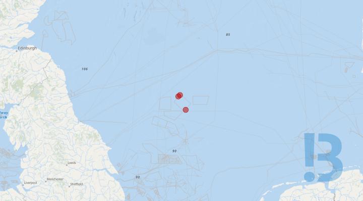
Navigational Warning - Demarcation Buoys - Sofia Offshore Wind Farm
Mariners are advised that a number of the Perimeter Buoyage that demarcates the Sofia Offshore Wind Farm as an area under construction have the Top Marks missing. There are also now 3 (three) perimeter buoys that have extinguished lights.
Those demarcation buoys that are now an unlit hazard during hours of Darkness are outlined below;
- N1 - 55° 08.13’ N x 002° 09.52’ E
- SP2 - 55° 06.57’ N x 002° 05.76’ E
- E5 - 54° 51.52’ N x 002° 20.71’ E
As N1 & SP2 are adjacent to each other, the Guard Vessel “Enterprise II” will position themselves in this vicinity during the hours of darkness (weather permitting) to monitor vessel traffic movements in the area and direct any vessels away from the unlit hazard.
This will be supplemented with regular safety broadcasts from the Enterprise II. The Guard Vessel will also monitor the array via AIS and Radar.
Sofia MCC will also monitor the Sofia Offshore Array remotely via AIS and has initiated triggered guard zones within areas of concern.
It is expected that the remedial programme will commence in approx. 7 days (weather permitting).
See detailed map on our bulletin website

UXO Identification Works - East Anglia 3 Offshore Wind Farm & Export Cable Route
UXO Identification using the vessel 'Glomar Wave' will take place at the East Anglia 3 (EA3) OWF & ECR. Work will begin inside the OWF site on approx 17 March 2024. The vessel will mobilise and initially transit from Gt Yarmouth to the site and will pause enroute to perform some trials and calibrations. A work class ROV and onboard survey and positioning equipment will be used. In the event any UXO's are located, the vessel will mobilise with a demolition spread at a date TBD (likely May/Jun)
The whole scope is expected to complete approx. August 2024.
More details to follow.
See detailed map on our bulletin website
Array Cable Installation - Moray Offshore Windfarm (West) Limited
This notice to mariners is to inform that Moray Offshore Windfarm (West) Limited (Moray West) will be carrying out array cable installation and ROV survey operations from the vessel Seaway Aimery supported by the Olympic Orion at the Moray West Offshore Wind Farm site.
Scope of work includes installation of subsea power cables into the Wind Turbine Generator foundations and Offshore Substation foundations. Followed by lay subsea power cables on the seabed (a separate NtM will be issued for cable burial operations in the future) Also an ROV survey of the array cable routes, and monitoring of the operation will be conducted.
The work will be performed by the Seaway Aimery supported by the Olympic Orion.
See detailed map on our bulletin website
Offshore Site Investigation - Awel y Môr Proposed Wind Farm
A Geotechnical Site Investigation of the proposed Awel y Môr Offshore Wind Farm is due to be conducted off the North Wales coast between 11th November 2023 and May 2024.
The jack-up barge Seafox 7 is due to start geotechnical site investigations on the 11th November 2023 and to continue the survey until May 2024. This estimate includes delays likely to be caused by bad weather. During the survey, Seafox 7 will drill 60 boreholes at discrete locations in the project site. The vessel will operate for 24 hours per day during the survey. The survey area is illustrated in the Notice to Mariners and bounded by the coordinates below:-
- NE Marker: 53° 29.460’N 003° 35.220’W
- SE Marker: 53° 29.532’N 003° 44.760’W
- SW Marker: 53° 26.700’N 003° 51.600’W
- NW Marker: 53° 29.280’N 003° 51.600’W
Seafox 7 will be supported by the vessels Elisa and Fairplay 32 in its daily operations, and these vessels will tow the barge between sampling locations. The tugs will standby at anchor on the project site, and will also be transiting between the site and nearby ports. The vessel MCS Boreas will be assisting the Seafox 7 with crew transfer operations to shore on a twice-weekly basis.
Vessel details
Seafox 7 is a jack-up barge with a red hull and white superstructure. It measures 55.5m long with a beam of 32.2m. Details for this barge and its support vessels are provided below:-
- Seafox 7: drilling vessel | MMSI 235065812 | Call sign 2BGC6
- Elisa: Support vessel / tug | MMSI 236745000 | Call sign PBZP
- Fairplay 32: Support vessel / tug | MMSI 210447000 | Call sign 5BAM6
- MCS Boreas: Crew Transfer Vessel | MMSI 235096501 | Call sign 2GDR8
Operations will be conducted on a 24 hour basis. A continuous listening watch will be conducted on VHF Channel 16.
Other vessels are requested to keep their distance, maintaining at least a 500m distance.
Full details of all of the vessels can be found in the Notice to Mariners.
About the proposed windfarm
The Awel y Môr Offshore Wind Farm would be built around six miles off the North Wales coast, to the west of the existing Gwynt y Môr windfarm. Awel y Môr would be connected to the National Grid by an export cable coming ashore between Rhyl and Prestatyn. The proposed windfarm would include up to 50 wind turbines. It could generate enough power for up to half a million homes, and it will be the largest renewable energy investment in Wales in this decade. Full project details and maps of the windfarm location are available at the project website awelymor.cymru.
See detailed map on our bulletin website
Geophysical Survey - Thistle Wind Partners proposed (E3) Offshore Wind Farm
Thistle Wind Partners are developing the proposed Bowdun (E3) Offshore Wind Farm. Please be advised that G-Tec, on behalf of Thistle Wind Partners (TWP), is undertaking a Geophysical Survey of the proposed Bowdun (E3) Offshore Wind Farm Array Area. The purpose of this Notice to Mariners (NtM) is to outline the working area for the survey vessel, as well as the scope of work. The survey will utilise the vessel Karina.
G-Tec will be undertaking a geophysical survey over Bowdun (E3) Area Area utilising towed sensors. During the survey the vessel will be operating at approximately 4 knots with equipment being towed at a distance of up to 300m astern of the vessel.
See detailed map on our bulletin website
Seawatch Wind Lidar Buoys - Caledonia Offshore Wind Farm
Deployment of two (2) Floating Seawatch Wind LiDAR buoys in the Moray Firth for the acquisition of Wind and Metocean Data for a period of 24 months.
*SWLB-075 currently unlit (04/03/2024) - AIS remains active*
On the 3rd of June 2023, Fugro deployed two (2) Floating Seawatch LiDAR buoys within the Caledonia Offshore Wind Farm site for the acquisition of Wind and Metocean Data. The two buoys are intended to remain in-situ for a minimum period of 24 months.
Mariners are advised to maintain a 500 m clearance from the deployed equipment. Operations were completed by the Fishing vessel ‘MS Elisabeth’.
The buoys will remain in situ until June 2025, the exact removal date will depend on weather and be determined at a later stage. A separate NtM will be issued for the removal activity.
Details on the Seawatch Wind LiDAR (3.0) Buoys including navigational safety features and mooring layout design are provided in the attached NtM (V8).
See detailed map on our bulletin website
Exposed Cable - Shefa-2 (Segment 7)
Shefa-2 Segment 7 cable break has been repaired and the Post Repair Inspection and Burial (PRIB) operation has been completed. Hence, minor sections of wet stored cable is sensitive to any external impacts and constitutes a snagging risk for anchoring, fishing gear or other equipment with seabed intervention.
Show More

Exposed Cable - Shefa-2 (Segment 7)
Shefa-2 Segment 7 cable breaks occurred 14 October 2022 and 11 May 2023. The Post Repair Inspection revealed that, due to rocky seabed, cable burial is not possible and other cable protection measures are being evaluated. Hence, a section of 2600m cable is exposed to seabed and poses a high risk to fishing activity. Please pay attention to this section of wet stored cable which is sensitive to any external impacts and constitutes a snagging risk for fishing, anchoring or other seabed equipment.
Show More

Metocean buoy at Bellorck Offshore Wind Farm site
Please be advised that EOLOS has successfully relocated the Bellrock Floating LiDAR System buoy FLIDAR E25 on 24th February 2024. The new coordinates are shown in Table 1 in the attached. The Bellrock FLS200 E25 will remain in the Bellrock Offshore Wind Farm site for an approximate period of 24 months (i.e. until April 2025).
Please be advised that EOLOS has successfully relocated the Bellrock Floating LiDAR System buoy FLIDAR E25 on 24th February 2024. The new coordinates are shown in Table 1 in the attached.
The Bellrock FLIDAR E25 was initially deployed within the Bellorck Offshore Wind Farm site in April 2023, for acquisition of Wind and Metocean Data. A description of the device is presented in Section 2 in the attached.
The works completed on the 24th February 2024, with the Voe Earl vessel, consisted of recovering the Bellrock FLIDAR E25 device from its original location, and redeploying it at the new location (See Table 1 and Figure 1 in the attached).
The Bellrock FLS200 E25 will remain in the Bellrock Offshore Wind Farm site for an approximate period of 24 months (i.e. until April 2025).
See detailed map on our bulletin website
Research Buoy Recovery - Morlais Demonstration Zone.
Notification of the recovery of scientific research buoy in the Morlais Demonstration Zone to the Port of Holyhead.
Show More

Exposed and Free Span - Greater Gabbard Offshore Wind Farm
Results of the Greater Gabbard OFTO export cable survey. The chart lists the changes to the exposures on the three export cables, on the inshore section between KP 3 and KP 5 with a free span remaining around KP 4. Between KP 36 and KP 38 there are some exposed sections as the cables enter the site. In addition, although listed as exposures on the chart, there are areas of shallow burial at KP10 and a cable exposure on the interconnector cable within the site.
Please find attached a chart showing the results of the Greater Gabbard OFTO export cable survey. The chart lists the changes to the exposures on the three export cables, on the inshore section between KP 3 and KP 5 with a free span remaining around KP 4. Between KP 36 and KP 38 there are some exposed sections as the cables enter the site. In addition, although listed as exposures on the chart, there are areas of shallow burial at KP10 and a cable exposure on the interconnector cable within the site.
The exposed/shallow burial areas are shown as the coloured dots on the cable route highlighted in a black box. Equitix (Greater Gabbard OFTO) have asked that all Fishermen operate with caution when fishing anywhere on the cable route and particularly the areas that are shallow buried around KP10.’
Coordinates of exposed/shallow burial areas are shown on the attached chart.
The OFTO is updating its risk assessments to determine the extent of remedial measures that may be required. Equitix intend to provide an update on remediation after the risk assessment exercise is complete.’
See detailed map on our bulletin website
Project Marine Survey Geotechnical Operations - Eastern Green Link 3
Mariners are advised that a marine geotechnical survey is planned for the Eastern Green Link 3 (EGL3) project. The marine survey activities for EGL 3 are planned to commence late-November 2023 and are expected to complete around the end of May 2024.
Eastern Green Link 3 is a HVDC electricity transmission interconnector between Scotland and England, a joint venture between National Grid and Scottish & Southern Electricity Transmission (SSEN).
The EGL 3 project will play a vital role in achieving the UK and Scottish governments net zero targets and significantly increase the UK’s capacity for clean, green renewable power.
The EGL 3 marine geotechnical survey works consist of shallow cone penetration tests (CPTs) and vibrocores (VCs) to a maximum of 6 m below seabed at approximate 1 km intervals.
The area of work, pertaining to this Notice to Mariners (NtM) for EGL 3, is illustrated in Figure 1, with the survey vessel contact details for the project found in Table 1. Note, centreline co-ordinates are provided on the associated Kingfisher notice.
Contact details for the project Fisheries Liaison Officers are detailed below.
The geotechnical survey works are being carried out by Next Geosolutions using the following vessel:
Ievoli Grey (IMO 9608788; MMSI 247325100; Call Sign IBCM).
Vessels are requested to pass at a safe speed and distance and fishing vessels are advised to remain a safe distance, approximately 550m (0.3 nautical miles) from the areas identified. During these works the vessel will have restricted manoeuvrability as it completes its work scope.
VHF CH 16 will be monitored at all times and will be used to contact the coastguard in the event of an emergency.
See detailed map on our bulletin website
Metocean Buoy Deployments - Ossian Offshore Wind Farm
Partrac Ltd. deployed FLS200 Floating LiDAR buoys at two sites within the Ossian Floating Offshore Wind Farm off the East coast of Scotland in August 2022. Partrac is planning to redeploy the LiDAR Buoy at Site 1, and recover the LiDAR Buoy at Site 3 to Montrose for maintenance, from 14/02/2024. The works are estimated to be carried out over two days, weather permitting. The vessel to be used for the works is the Voe Earl with call sign 2FEP6, MMSI Number 235090599 and IMO 9639983.
FLOATING LIDAR BUOY The floating LiDAR buoys deployed at sites 1 and 3 record meteorological data and are anchored to the seabed by means of a mooring chain and a ground weight. The buoy has dimensions of 4m x 4m, and when deployed the tallest mast on the buoy sits approx. 4m above the water line. The lantern has a flash sequence Fl (5) Y 20s. Please maintain a 500m exclusion around each buoy.
See detailed map on our bulletin website
Navigational Hazard due to cable exposure - AEC-1
AEC-1 Cable System break has been repaired but the Post Repair Inspection and Burial (PRIB) operation has not been completed. Hence, a section of approx. 1.5km of cable is sensitive to any external impacts and constitutes a snagging risk for anchoring, fishing gear or other equipment with seabed intervention. Please keep a distance of 500m.
Show More

Rampion Offshore Wind Farm Notice To Mariners: Risk of cable exposure within the Rampion Wind Farm
Following the most recent subsea survey carried out in August 2023, updated information of inter-array cable exposures are listed and illustrated below. Analysis of survey data at the wind farm indicates the locations of exposures of sections of inter-array cables are subject to change resulting from dynamic movements of the seabed but are primarily focused within the South-South East of the wind farm area.
Following the most recent subsea survey carried out in August 2023, updated information of inter-array cable exposures are listed and illustrated below. Analysis of survey data at the wind farm indicates the locations of exposures of sections of inter-array cables are subject to change resulting from dynamic movements of the seabed but are primarily focused within the South-South East of the wind farm area.
Mariners are reminded that further safety information related to array cable exposures can be found in “The Risks of Fishing Near Cables and Renewable Energy Structures”, published on the KIS-ORCA website https://kis-orca.org/safety/the-risks-of-fishing-near-cables-renewable-energy-structures/. General safety information can be found here: https://www.seafish.org/article/kingfisher-bulletins.. All mariners are requested to make themselves aware of their obligations for conducting activities over buried and protected cables under International and UK Cable (Subsea) Protection Legislation.
See detailed map on our bulletin website
Risk of cable exposure within the Galloper Offshore Windfarm
Galloper Windfarm, RWE - NTM: GWFL-O&M 03-2020 v2 Risk of cable exposure within the Galloper Windfarm
Please be advised that the subsea survey carried out in 2020, identified seven cable routes with 10 exposures in total. The below table provides the locations of the identified exposures.
As cable exposure is a known risk at Galloper and across the offshore wind industry, we would remind Mariners of the safety information found on the KIS-ORCA website ‘The risks of fishing near cables and renewable energy structures. To avoid crossing cables when towing equipment follow the cable corridors- locations of the cables can be found on the Galloper awareness charts via KIS-ORCA.
See detailed map on our bulletin website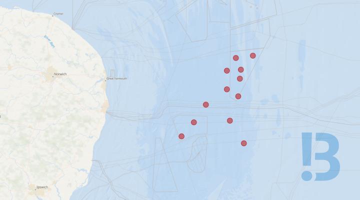
Marine Mammal Monitoring Passive Acoustic Monitoring Deployment - East Anglia Offshore Windfarm
Seiche limited has deployed 12 Passive Acoustic Monitoring (PAM) Stations on the seabed in the East Anglia Offshore Windfarm Area on the 16th of May 2023. The PAM stations will remain on the seabed till the 31st of October 2027. The PAM stations have 12 m height above the seabed, they weigh 600 kg and their location will not be marked by a surface buoy. All marine traffic is advised to maintain 500 m exclusion zone around these PAM locations for their safety.
East Anglia THREE Offshore Windfarm Marine Mammal Monitoring - Passive Acoustic Monitoring Baseline Deployment
• Seiche Limited
• Passive Acoustic Monitoring at the East Anglia Three Offshore Windfarm
• NTM: PAM-EA3- 007 Date of issue: 09 January 2024
Dear Owners, Ships Agents, Masters, Pilots and Fishermen,
Please, be advised that Seiche Limited will perform a Service on the 12 Passive Acoustic Monitoring (PAM) Stations that had been deployed on the seabed in and at locations around the East Anglia THREE Offshore Windfarm Area, starting from the 27th of January 2024. The service is expected to be completed on the 10th of February 2024.
Seiche will utilise the Reykjanes vessel for the deployment.
Reykjanes
Scope: PAM stations deployment
Vessel: Reykjanes
LOA: 40.16 m
Call sign: OVSI2
IMO: 7392311
MMSI: 219329000
Phone: +45 (0) 8213 6973
Mobile: +45 (0) 2614 9844
The PAM stations will remain on the seabed until approximately the 31st of October 2027. The PAM stations have 12 m height above the seabed, they weigh 600 kg and their location will not be marked by a surface buoy.
All marine traffic is advised to maintain 500 m safety zone around the Reykjanes or any other vessel at these locations during deployment or servicing for their safety.
There is an exclusion zone of 250 m around the PAM Stations. All marine traffic is advised to abide by the 250 m safety zone around the PAM Stations all the time for their safety.
/Locations of the PAM stations in WGS-84 coordinates:
|
Date Deployed |
Location Number |
Latitude |
Longitude |
For general enquiries, please, contact via e-mail: environmental@seiche.com https://www.seiche.com/ Tel: +44 (0) 1409 404050
Fisheries Liaison Officer (FLO): Name: Jonathan Keer // Freya Sandison Email: jonathan@brownmay.com // molly.jones@brownmay.com Telephone: +44 (0) 7850 604851 // +44 (0) 7857 500609 |
|||
|
16 May 23 |
EA3_01 |
52° |
39.757' |
N |
002° |
50.892' |
E |
|
16 May 23 |
EA3_02 |
52° |
43.944' |
N |
002° |
56.888' |
E |
|
16 May 23 |
EA3_03 |
52° |
43.323' |
N |
002° |
48.350' |
E |
|
16 May 23 |
EA3_04 |
52° |
39.478' |
N |
002° |
43.975' |
E |
|
16 May 23 |
EA3_05 |
52° |
33.833' |
N |
002° |
43.954' |
E |
|
16 May 23 |
EA3_06 |
52° |
29.218' |
N |
002° |
33.556' |
E |
|
16 May 23 |
EA3_07 |
52° |
23.948' |
N |
002° |
27.678' |
E |
|
16 May 23 |
EA3_08 |
52° |
19.731' |
N |
002° |
21.606' |
E |
|
16 May 23 |
EA3_09 |
52° |
37.079' |
N |
002° |
50.340' |
E |
|
16 May 23 |
EA3_10 |
52° |
31.734' |
N |
002° |
49.630' |
E |
|
16 May 23 |
EA3_11 |
52° |
24.449' |
N |
002° |
45.480' |
E |
|
16 May 23 |
EA3_12 |
52° |
17.573' |
N |
002° |
52.304' |
E |
This notification supersedes all previous notifications issued in relation to this activity.
See detailed map on our bulletin website
Surface Laid Cable - The Whitley Bay Stub Route (2)
The installation of the Havhingsten fibre optic telecommunication Whitley Bay Stub Route has been completed. Due to challenging soil conditions and rocky seabed, there are sections of surface laid cable and areas with shallow burial. No further operations to bury this section of cable are planned due to the presence of rock. The cable is protected by the armoured cable type and from the BMH up to kilometre point (KP) 0.474 the cable is additionally protected by Articulated Pipe.
Please be advised that installation of the Havhingsten fibre optic telecommunication Whitley Bay Stub Route has been completed.
The supplier of the Havhingsten cable is Alcatel Submarine Networks (ASN). Intertek are the environmental and permitting consultants.
The Whitley Bay Stub Route has been installed between the Beach Man Hole (BMH) and the territorial sea limit but it will not yet be connected to the telecommunication network. This cable is to provide infrastructure for the network to expand relatively easily when demand is required within the next 10 - 15 years.
Due to challenging soil conditions and rocky seabed, there are sections of surface laid cable and areas with shallow burial (less than 0.20m burial depth), coordinates can be found below. No further operations to bury these sections of cable are planned due to the challenging soil conditions. The cable is protected by the armoured cable type and from the BMH up to kilometre point (KP) 0.474 the cable is additionally protected by Articulated Pipe.
Coordinates for the surface laid cable and shallow burial areas are provided in the attached Notice to Mariners.
Post-Lay Inspection & Burial (PLIB) by jetting for the section of surface laid cable close to the territorial sea limit was completed on the 1 November 2022.
See detailed map on our bulletin website
Passive Acoustic Monitoring Device - Spiorad na Mara Offshore Wind Farm
The Scottish Association for Marine Science (SAMS) using the Seatrek vessel Lochlann has successfully deployed a Passive Acoustic Monitoring Device (PAM) on behalf of Spiorad na Mara Ltd. The PAM will be deployed on site over a period of 12 months within the Spiorad na Mara offshore wind farm site.
Positions of equipment can be seen in Figure and Table 1 of attached.
See detailed map on our bulletin website
Metocean Equipment - Spiorad na Mara
Spiorad na Mara Ltd deployed an array of metocean equipment, including one floating LiDAR (FLIDAR) buoy, over a period of 24 months, and two Datawell Waverider buoys and one Seabed mooring for 12 months within the Spiorad na Mara offshore wind farm site. An additional seabed mooring has been deployed on site. The original seabed mooring remains without a surface buoy attached. there is approximately 100m of rope attached. Please keep clear.
Show More

Monopile / Transition Piece Offshore Installation - Moray Offshore Windfarm (West) Limited
This notice to mariners is to inform that Moray Offshore Windfarm (West) Limited (“Moray West”) will be commencing with the installation of Transition Pieces (TP) at the Moray West Offshore Wind Farm (Windfarm Marine License MS-00009774) from around 23 January 2024. The work comprises of the installation of 60x TPs on the already installed Monopiles. The TPs will be installed by the Jack up vessel Apollo.
The scope of TP installation with Apollo comprises of the installation of 60x WTG TPs and the scope of works for the MP installation with Orion comprises of the installation of approx. 30x MPs.
The TP installation will be carried out with the dynamically positioned installation Jack Up Vessel (JUV) Apollo. The MP installation will be carried out by the dynamically positioned installation vessel Orion in addition to the Bokalift 2.
See detailed map on our bulletin website

WTG Installation Campaign - Dogger Bank A
The Jack-up WTG Installation Vessel, Voltaire, will install wind turbine generators (WTG) within the Dogger Bank A construction area.
The works will commence on the 05th of July 2023, continuing until approximately Q2 2024. The works will be continuous, 24 hours a day. A chart of the DBA construction area boundary coordinates and a table of WTG location coordinates is provided below. A running list of the completed WTG installations and the next locations to be installed is presented in the Weekly Notice of Operations.
During operations, the Voltaire will be restricted in its ability to manoeuvre as defined under COLREGs (International Regulations for Preventing Collisions at Sea 1972) and will display the appropriate day shapes and lights. The vessel will also transmit an Automatic Identification System (AIS) message.
During operations, a Statutory Safety zone of 500m radius will be in place around the Voltaire during the installation of WTGs. The safety zone will be monitored by a guard vessel. The primary response will be to warn passing traffic of the ongoing works and any active safety zones, and to alert any vessels where an infringement may occur or has occurred.
See detailed map on our bulletin website
Abandoned fishing equipment/seabed fastener - Exa Hibernia Segment C
Fouled fishing equipment. Following on from a repair completed to the Hibernia/Exa Dublin – Southport cable, abandoned trawl equipment fouled on the seabed and very close to the submarine cable has been identified in position 53 48.2166N 04 28.7343W
All fishermen are strongly advised to avoid fishing in this area, giving a minimum clearance of 0.25 nautical miles from this abandoned fishing equipment, to avoid risk of further fouling and/or entanglement with the Hibernia/Exa cable and therefore possible endangerment to the vessel and its crew.
See detailed map on our bulletin website
Floating LiDAR and Metocean Survey Deployment - MachairWind Offshore Wind Farm
A floating LiDAR buoy, surface metocean equipment buoys and seabed landers have been deployed at two sites to assist with the development of MachairWind Offshore Wind Farm. The floating LiDAR buoy and metocean equipment was deployed between 28th April – 29th April 2023 by Fugro from the Port of Burntisland. The Forth Warrior vessel deployed the floating LiDAR and Metocean survey equipment. Mariners are requested to keep a distance of 500 metres from the Site 1 and Site 2 deployment locations.
The floating LiDAR buoy, surface metocean equipment buoys and seabed landers have been deployed at two separate locations. The equipment deployed will gather wind and metocean data which will be used to inform the development of the Project.
The Floating LiDAR buoy , Metocean Midi Buoy and Metocean Wavescan Buoy are all surface buoys, tethered to the sea bed with single mooring lines. The Seabed Lander is a frame anchored on the seabed, approximately 1.7 m diameter and 0.6 m high.
The Floating LiDAR buoy, Metocean Midi Buoy and Metocean Wavescan Buoy have light marking characteristics comprising FI (5) Y 20s with a nominal range of 5 nautical miles.
Surface equipment at Site 1 and Site 2 are transmitting their locations via AIS.
Equipment details and mooring designs of the floating LiDAR buoy, metocean buoys and seabed lander are provided in this notice to mariners.
See detailed map on our bulletin website
Installation of Monopile foundations - Moray West offshore wind farm
This notice to mariners is to inform that Moray Offshore Windfarm (West) Limited (Moray West) will be commencing Monopile, Transition Piece and Offshore Substation installation works at the Moray West Offshore Wind Farm
(Windfarm Marine Licence MS-00009774) installation from and no earlier than 1 October 2023. The first work scope, which will be undertaken, is the installation of Monopiles from the 1 October 2023.
Please be aware that, during the Monopile installation works, the Bokalift 2, by virtue of its mode of operation the vessel, will be Restricted in its Ability to Manoeuvre (RAM). Masters of vessels are requested to maintain their vessels and gears at a minimum safe passing distance from the vessel of 500 meters when it is undertaking work and showing the appropriate shapes and lights in accordance with COLREGs Rule 27 (International Regulations for Preventing Collisions at Sea 1972, Rule 3).
The scope of work includes the installation of Monopiles and Transition Pieces at 62 foundation locations, and the installation of two Offshore Substations. The installation of Monopiles and Topsides will be carried out with dynamically positioned installation vessels.
The installation of the Transition Pieces will be carried out from a jack-up vessel. A separate Notice to Mariners will be issued ahead of the start of Offshore Substation installation and ahead of the Transition Piece installation works.
See detailed map on our bulletin website
Marine Hazard and Archaeological Exclusion Zone - Dogger Bank C Export Cable
A new marine hazard has been identified during UXO identification and investigation operations in the Dogger Bank C export cable corridor.
The marine hazard is located on the seabed in the near vicinity of the intended route of the DBC export cable and is a group of metallic objects associated with military (probably WW2) activity in nature.
A 50 metre Archaeological Exclusion Zone (AEZ) has been implemented under the terms of the Written Scheme of Investigation (WSI) produced and agreed with Historic England as per Licence condition in accordance with 16(g) of dML 1 and Condition 13(g) of dML 3.
Fishing vessels and other vessels engaged in the deploying of sub-surface and bottom interacting gear should avoid the area.
See detailed map on our bulletin website
Nearshore Works Temporary Marker Buoy - Dogger Bank C
The nearshore works to prepare for installation of the Dogger Bank C export cable have now been completed. The temporary marker buoy will remain in position in the vicinity of the Horizontal Directional Drill (HDD) North and South exit points as shown in the graphic inlcuded with this notice with a chart of the general area where the temporary marker buoy is located. The characteristics of the temporary marker buoy are included in this notice.
Show More

Potentially exposed cable - Caithness Moray HVDC link
Scottish Hydro Electric Transmission Plc has become aware of two areas of potential cable exposure on the Caithness Moray HVDC link, and request that a 500m safety zone is observed
Scottish Hydro Electric Transmission Plc has become aware of two areas of potential cable exposure on the Caithness Moray HVDC link, and request that a 500m safety zone is observed centred on the co-ordinates below.
|
KP |
Longitude (WGS 84) |
Latitude (WGS 84) |
|
99.240 |
-2.8633908494 |
58.4590588736 |
|
105.282 |
-2.9656976221 |
58.4615448756 |
Mariners are requested not to anchor or tow equipment inside the 500m safety zone surrounding the potentially exposed cable, as this would pose a risk of both snagging and / or damage to vessels, gear and the Caithness Moray HVDC link.
This email serves as notification under condition 35 of licence 04368/18/2
See detailed map on our bulletin website

Floating LiDAR and Metocean Survey - Muir Mhòr Offshore Wind Farm
Metocean instrumentation and a floating LiDAR system (FLS) have been deployed within the boundary of the proposed Muir Mhòr Offshore Wind Farm Project site. All instrumentation was deployed by Green Rebel from the Port of Aberdeen to the site in February 2023 via the vessel BB Ocean (IMO 9196503, MMSI 258825000). MARINE USERS are requested to maintain a safe clearance distance of 500m from all assets. May 2023: Northern Guard Buoy no longer present, replacement process is ongoing.
All instrumentation is deployed at a single deployment location within the project site. The purpose of the instrumentation is to gather Metocean and wind data to inform the proposed Muir Mhor Offshore Wind Farm Project.
The FLS mooring comprises of a surface visible buoy moored to the seabed via a two-point mooring system constructed using a combination of rope and chain. Two guard buoys are located at approximately 30m from the main FLS buoy in a North/South orientation, with the mooring spread covering an approximate 315m radius. There is also a seabed frame for current measurements contained within the overall deployment footprint, approximately 30m East of the main FLS buoy. Note: there are 2x orange polyform marker buoys located above the northern anchor position (detailed below) which will be removed during the first planned maintenance visit.
The FLS light characteristics are Fl (5) Y 20s with 5nm range. The guard buoys’ light characteristics are FI Y 5s with 3nm range and include a yellow St. Andrew’s Cross topmark. The FLS is designated as “Muir Mhor Floating Lidar” on AIS, with MMSI number 992351400.
Details of the surface visible buoy, guard buoys, seabed frame and mooring arrangement are provided in the attachments.
MARINE USERS are requested to maintain a safe clearance distance of 500m from all assets.
See detailed map on our bulletin website


Disclaimer
TO DOWNLOAD THIS FILE, YOU MUST AGREE TO THE TERMS AND CONDITIONS "TERMS" NOTED AT THE FOOT OF THIS WEBSITE WHICH APPLY TO YOUR USE OF THIS WEBSITE AND TO USE OF THE FILE YOU HAVE CLICKED TO DOWNLOAD. IF YOU DO NOT AGREE TO THE TERMS, YOU WILL NOT BE ABLE TO DOWNLOAD THE FILE AND YOU SHOULD NOT USE THIS WEBSITE. TO CONFIRM YOUR ACCEPTANCE OF THE TERMS AND TO COMMENCE THE DOWNLOAD OF THE FILE, PLEASE CLICK THE "DOWNLOAD" CHECK BOX. IF YOU DO NOT AGREE TO THE TERMS, PLEASE CLICK THE "CANCEL" BUTTON. YOUR ATTENTION IS DRAWN TO CONDITION 3 NOTED BELOW WHICH FORMS PART OF THE TERMS IN RELATION TO OUR LIABILITY TO YOU.
Agree and download Cancel